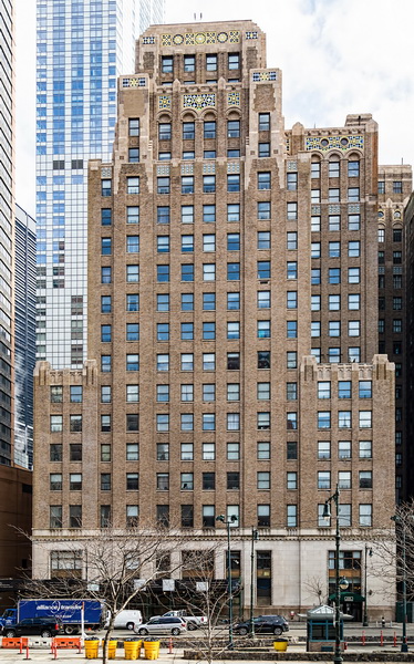
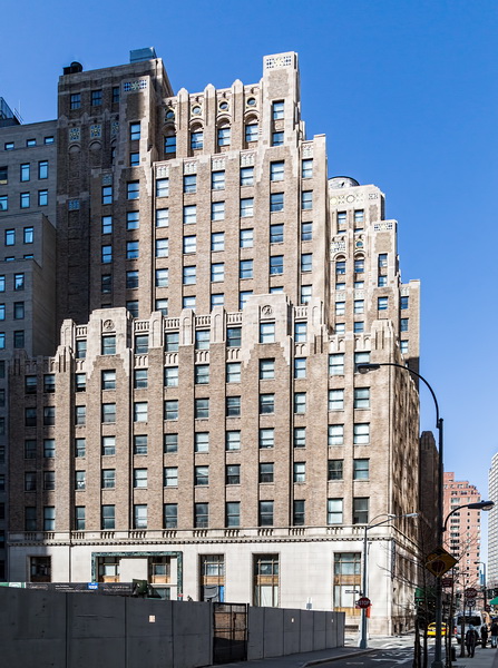
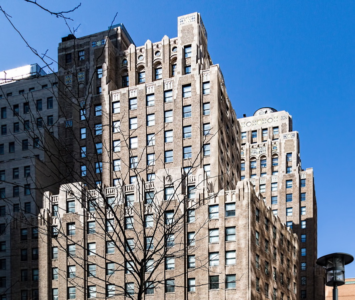
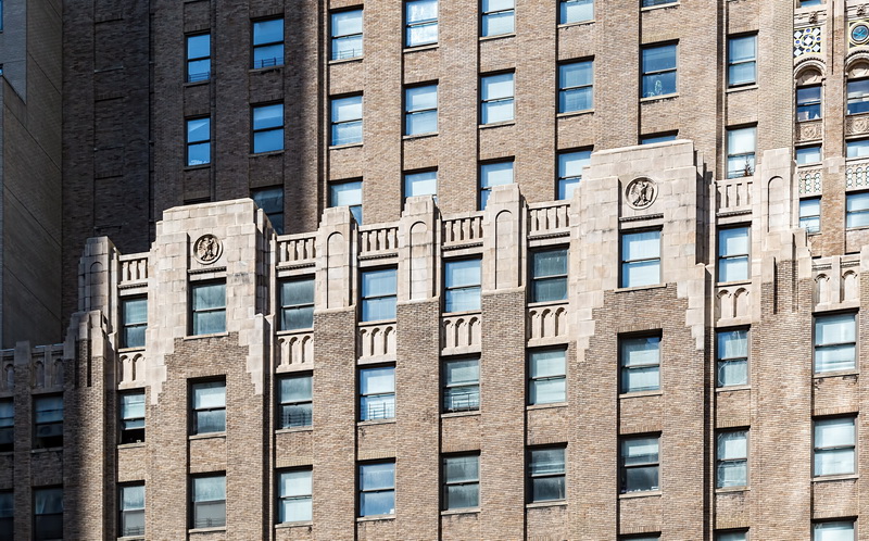
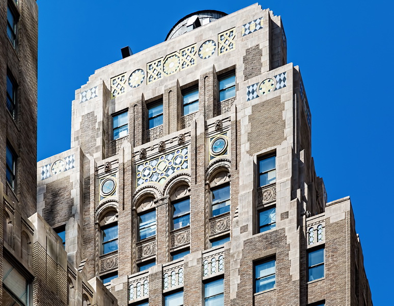
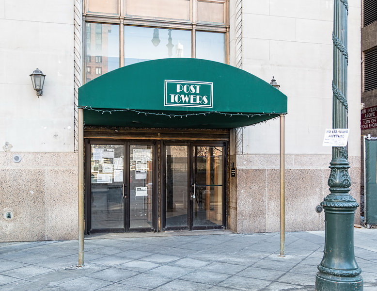
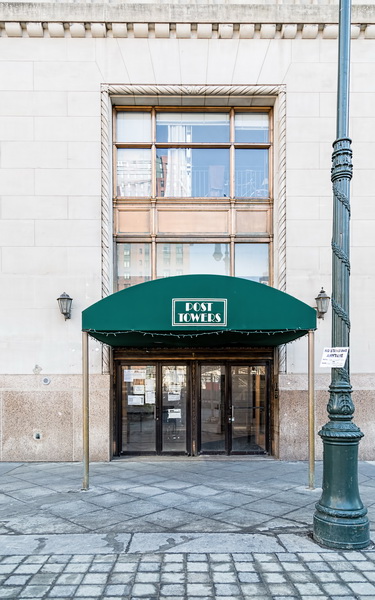
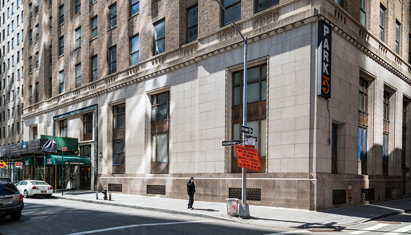
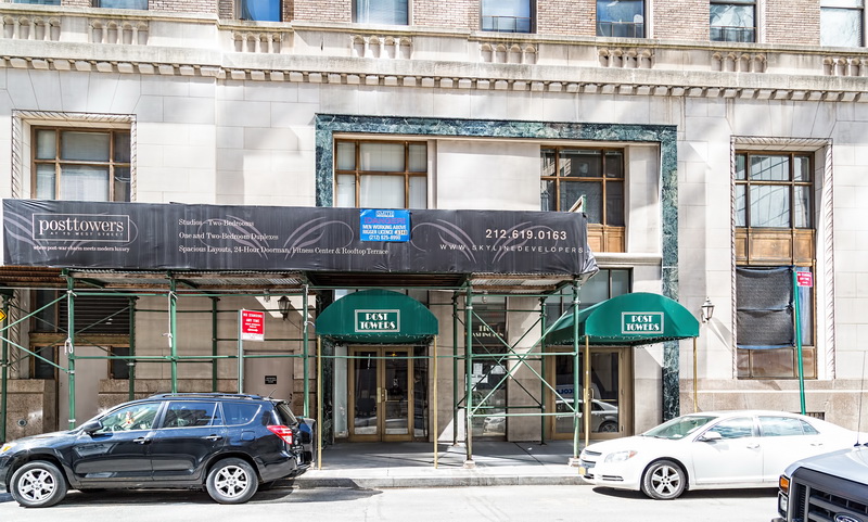
Post Towers, built in 1926 as the New York Evening Post Building, is a residential conversion in New York’s Financial District. The 21-story Art Deco building was the Post’s second headquarters, after the landmark building on Vesey Street.
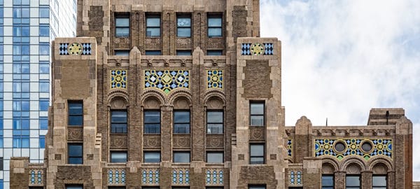
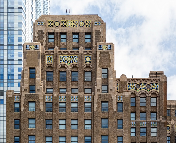
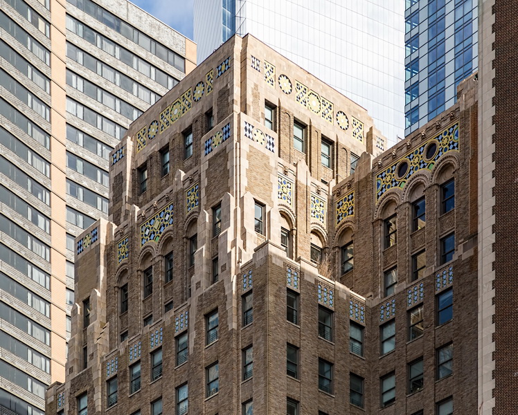
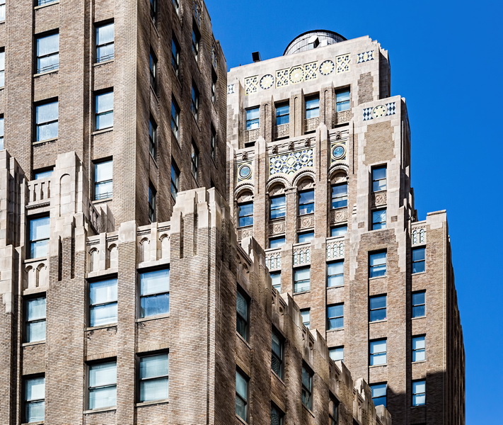
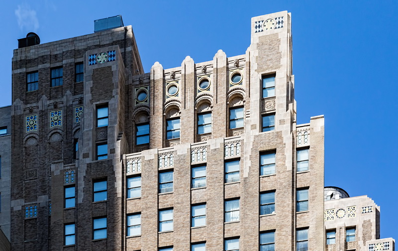
Post Towers’ architectural distinction is the colorful geometric terra cotta design in the crown. This was recently cleaned and restored, and is best seen from across West Street.
When built, this (and all buildings on the east side of West Street) was on the waterfront. Battery Park City is built on landfill from the excavation for the original World Trade Towers.
Post Towers Vital Statistics
- Location: 75 West Street at Carlisle Street
- Year completed: 1926; converted to residential 1998
- Architect: Horace Trumbauer; conversion by Costas Kondylis
- Floors: 21
- Style: Art Deco
- National Register of Historic Places: 2000
Post Towers Recommended Reading
- Wikipedia entry
- The New York Times Residential Real Estate; Downtown Building Joins in a Conversion Trend (May 22, 1998)
- Street Easy NY listing (includes floor plans)
- City Realty review
- Emporis database
- Garden Communities (building management) website
![New York by Gehry: NYG_0009 [] New York by Gehry: NYG_0009 []](https://www.newyorkitecture.com/wp-content/gallery/new-york-by-gehry/NYG_0009.jpg)
![New York by Gehry: NYG_0014 [] New York by Gehry: NYG_0014 []](https://www.newyorkitecture.com/wp-content/gallery/new-york-by-gehry/NYG_0014.jpg)
![New York by Gehry: NYG_0010 [] New York by Gehry: NYG_0010 []](https://www.newyorkitecture.com/wp-content/gallery/new-york-by-gehry/NYG_0010.jpg)
![New York by Gehry: NYG_0008 [] New York by Gehry: NYG_0008 []](https://www.newyorkitecture.com/wp-content/gallery/new-york-by-gehry/NYG_0008.jpg)
![IMG_3118_19_20Adjust [3/7/2012 4:12:16 PM] IMG_3118_19_20Adjust [3/7/2012 4:12:16 PM]](https://www.newyorkitecture.com/wp-content/gallery/battery-park-city/img_3118_19_20adjust.jpg)
![BAT_04_P8060029 [8/6/2011 11:22:11 AM] BAT_04_P8060029 [8/6/2011 11:22:11 AM]](https://www.newyorkitecture.com/wp-content/gallery/battery-battery-park/bat_04_p8060029.jpg)
![IMG_0588 [12/1/2011 12:02:50 PM] IMG_0588 [12/1/2011 12:02:50 PM]](https://www.newyorkitecture.com/wp-content/gallery/battery-battery-park/img_0588.jpg)
![BAT_05_P8050101 [8/5/2011 3:32:33 PM] BAT_05_P8050101 [8/5/2011 3:32:33 PM]](https://www.newyorkitecture.com/wp-content/gallery/battery-battery-park/bat_05_p8050101.jpg)
![BAT_05_0649 [7/27/2011 8:45:30 AM] BAT_05_0649 [7/27/2011 8:45:30 AM]](https://www.newyorkitecture.com/wp-content/gallery/battery-battery-park/bat_05_0649.jpg)
![BAT_05_0648 [7/27/2011 8:41:54 AM] BAT_05_0648 [7/27/2011 8:41:54 AM]](https://www.newyorkitecture.com/wp-content/gallery/battery-battery-park/bat_05_0648.jpg)
![BAT_05_0647 [7/27/2011 8:41:09 AM] BAT_05_0647 [7/27/2011 8:41:09 AM]](https://www.newyorkitecture.com/wp-content/gallery/battery-battery-park/bat_05_0647.jpg)
![BAT_05_0646 [7/27/2011 8:39:36 AM] BAT_05_0646 [7/27/2011 8:39:36 AM]](https://www.newyorkitecture.com/wp-content/gallery/battery-battery-park/bat_05_0646.jpg)
![BAT_05_0635 [12/1/2011 12:17:32 PM] BAT_05_0635 [12/1/2011 12:17:32 PM]](https://www.newyorkitecture.com/wp-content/gallery/battery-battery-park/bat_05_0635.jpg)
![BAT_05_0634 [12/1/2011 12:21:17 PM] BAT_05_0634 [12/1/2011 12:21:17 PM]](https://www.newyorkitecture.com/wp-content/gallery/battery-battery-park/bat_05_0634.jpg)
![BAT_00__3933 [10/22/2011 9:05:05 AM] BAT_00__3933 [10/22/2011 9:05:05 AM]](https://www.newyorkitecture.com/wp-content/gallery/battery-battery-park/bat_00__3933.jpg)
![BAT_04_P8060018 [8/6/2011 11:05:50 AM] BAT_04_P8060018 [8/6/2011 11:05:50 AM]](https://www.newyorkitecture.com/wp-content/gallery/battery-battery-park/bat_04_p8060018.jpg)
![BAT_03_P8040004 [8/4/2011 11:41:57 AM] BAT_03_P8040004 [8/4/2011 11:41:57 AM]](https://www.newyorkitecture.com/wp-content/gallery/battery-battery-park/bat_03_p8040004.jpg)
![BAT_02_09913 [11/30/2011 10:27:55 AM] BAT_02_09913 [11/30/2011 10:27:55 AM]](https://www.newyorkitecture.com/wp-content/gallery/battery-battery-park/bat_02_09913.jpg)
![BAT_02_09905 [11/30/2011 10:25:59 AM] BAT_02_09905 [11/30/2011 10:25:59 AM]](https://www.newyorkitecture.com/wp-content/gallery/battery-battery-park/bat_02_09905.jpg)
![BAT_01_P8060004 [8/6/2011 10:50:31 AM] BAT_01_P8060004 [8/6/2011 10:50:31 AM]](https://www.newyorkitecture.com/wp-content/gallery/battery-battery-park/bat_01_p8060004.jpg)
![BAT_01_P8060001 [8/6/2011 10:49:31 AM] BAT_01_P8060001 [8/6/2011 10:49:31 AM]](https://www.newyorkitecture.com/wp-content/gallery/battery-battery-park/bat_01_p8060001.jpg)
![BAT_01_3512 [10/20/2011 3:59:24 PM] BAT_01_3512 [10/20/2011 3:59:24 PM]](https://www.newyorkitecture.com/wp-content/gallery/battery-battery-park/bat_01_3512.jpg)
![WAT_15_10163 [11/30/2011 12:04:43 PM] WAT_15_10163 [11/30/2011 12:04:43 PM]](https://www.newyorkitecture.com/wp-content/gallery/water-street-corridor/wat_15_10163.jpg)
![WAT_10_09968 [11/30/2011 10:53:58 AM] WAT_10_09968 [11/30/2011 10:53:58 AM]](https://www.newyorkitecture.com/wp-content/gallery/water-street-corridor/wat_10_09968.jpg)
![WAT_10_10003 [11/30/2011 11:02:35 AM] WAT_10_10003 [11/30/2011 11:02:35 AM]](https://www.newyorkitecture.com/wp-content/gallery/water-street-corridor/wat_10_10003.jpg)
![WAT_10_10121 [11/30/2011 11:46:52 AM] WAT_10_10121 [11/30/2011 11:46:52 AM]](https://www.newyorkitecture.com/wp-content/gallery/water-street-corridor/wat_10_10121.jpg)
![WAT_10a_10032 [11/30/2011 11:14:33 AM] WAT_10a_10032 [11/30/2011 11:14:33 AM]](https://www.newyorkitecture.com/wp-content/gallery/water-street-corridor/wat_10a_10032.jpg)
![WAT_11_2433 [12/4/2011 2:54:55 PM] WAT_11_2433 [12/4/2011 2:54:55 PM]](https://www.newyorkitecture.com/wp-content/gallery/water-street-corridor/wat_11_2433.jpg)
![WAT_11_10566 [11/30/2011 2:46:42 PM] WAT_11_10566 [11/30/2011 2:46:42 PM]](https://www.newyorkitecture.com/wp-content/gallery/water-street-corridor/wat_11_10566.jpg)
![WAT_11_10569 [11/30/2011 2:47:46 PM] WAT_11_10569 [11/30/2011 2:47:46 PM]](https://www.newyorkitecture.com/wp-content/gallery/water-street-corridor/wat_11_10569.jpg)
![WAT_12_10130 [11/30/2011 11:53:33 AM] WAT_12_10130 [11/30/2011 11:53:33 AM]](https://www.newyorkitecture.com/wp-content/gallery/water-street-corridor/wat_12_10130.jpg)
![WAT_12a_P8130100 [8/13/2011 1:46:38 PM] WAT_12a_P8130100 [8/13/2011 1:46:38 PM]](https://www.newyorkitecture.com/wp-content/gallery/water-street-corridor/wat_12a_p8130100.jpg)
![WAT_13_2439 [12/4/2011 2:56:52 PM] WAT_13_2439 [12/4/2011 2:56:52 PM]](https://www.newyorkitecture.com/wp-content/gallery/water-street-corridor/wat_13_2439.jpg)
![WAT_13_2463 [12/4/2011 3:00:16 PM] WAT_13_2463 [12/4/2011 3:00:16 PM]](https://www.newyorkitecture.com/wp-content/gallery/water-street-corridor/wat_13_2463.jpg)
![WAT_13_10160 [11/30/2011 12:03:07 PM] WAT_13_10160 [11/30/2011 12:03:07 PM]](https://www.newyorkitecture.com/wp-content/gallery/water-street-corridor/wat_13_10160.jpg)
![WAT_13a_10157 [11/30/2011 12:02:24 PM] WAT_13a_10157 [11/30/2011 12:02:24 PM]](https://www.newyorkitecture.com/wp-content/gallery/water-street-corridor/wat_13a_10157.jpg)
![WAT_10_09965 [11/30/2011 10:53:39 AM] WAT_10_09965 [11/30/2011 10:53:39 AM]](https://www.newyorkitecture.com/wp-content/gallery/water-street-corridor/wat_10_09965.jpg)
![WAT_15_10169 [11/30/2011 12:06:47 PM] WAT_15_10169 [11/30/2011 12:06:47 PM]](https://www.newyorkitecture.com/wp-content/gallery/water-street-corridor/wat_15_10169.jpg)
![WAT_15_10178 [11/30/2011 12:08:17 PM] WAT_15_10178 [11/30/2011 12:08:17 PM]](https://www.newyorkitecture.com/wp-content/gallery/water-street-corridor/wat_15_10178.jpg)
![WAT_15_10199 [11/30/2011 12:16:19 PM] WAT_15_10199 [11/30/2011 12:16:19 PM]](https://www.newyorkitecture.com/wp-content/gallery/water-street-corridor/wat_15_10199.jpg)
![WAT_16_10187 [11/30/2011 12:10:27 PM] WAT_16_10187 [11/30/2011 12:10:27 PM]](https://www.newyorkitecture.com/wp-content/gallery/water-street-corridor/wat_16_10187.jpg)
![WAT_16_10234 [11/30/2011 12:27:11 PM] WAT_16_10234 [11/30/2011 12:27:11 PM]](https://www.newyorkitecture.com/wp-content/gallery/water-street-corridor/wat_16_10234.jpg)
![WAT_16_10238 [11/30/2011 12:29:08 PM] WAT_16_10238 [11/30/2011 12:29:08 PM]](https://www.newyorkitecture.com/wp-content/gallery/water-street-corridor/wat_16_10238.jpg)
![WAT_17_10517 [11/30/2011 2:28:01 PM] WAT_17_10517 [11/30/2011 2:28:01 PM]](https://www.newyorkitecture.com/wp-content/gallery/water-street-corridor/wat_17_10517.jpg)
![WAT_17_10554 [11/30/2011 2:39:28 PM] WAT_17_10554 [11/30/2011 2:39:28 PM]](https://www.newyorkitecture.com/wp-content/gallery/water-street-corridor/wat_17_10554.jpg)
![WAT_17_10557 [11/30/2011 2:39:55 PM] WAT_17_10557 [11/30/2011 2:39:55 PM]](https://www.newyorkitecture.com/wp-content/gallery/water-street-corridor/wat_17_10557.jpg)
![WAT_18_10288 [11/30/2011 12:44:01 PM] WAT_18_10288 [11/30/2011 12:44:01 PM]](https://www.newyorkitecture.com/wp-content/gallery/water-street-corridor/wat_18_10288.jpg)
![WAT_19_10297 [11/30/2011 12:46:03 PM] WAT_19_10297 [11/30/2011 12:46:03 PM]](https://www.newyorkitecture.com/wp-content/gallery/water-street-corridor/wat_19_10297.jpg)
![WAT_19_10503 [11/30/2011 2:26:37 PM] WAT_19_10503 [11/30/2011 2:26:37 PM]](https://www.newyorkitecture.com/wp-content/gallery/water-street-corridor/wat_19_10503.jpg)
![WAT_00_P9160093 [9/16/2011 11:05:17 AM] WAT_00_P9160093 [9/16/2011 11:05:17 AM]](https://www.newyorkitecture.com/wp-content/gallery/water-street-corridor/wat00_p9160093.jpg)
![WAT_05_10051 [11/30/2011 11:20:47 AM] WAT_05_10051 [11/30/2011 11:20:47 AM]](https://www.newyorkitecture.com/wp-content/gallery/water-street-corridor/wat_05_10051.jpg)
![WAT_00_09913 [11/30/2011 10:27:55 AM] WAT_00_09913 [11/30/2011 10:27:55 AM]](https://www.newyorkitecture.com/wp-content/gallery/water-street-corridor/wat_00_09913.jpg)
![WAT_01_09921 [11/30/2011 10:32:29 AM] WAT_01_09921 [11/30/2011 10:32:29 AM]](https://www.newyorkitecture.com/wp-content/gallery/water-street-corridor/wat_01_09921.jpg)
![WAT_01_09925 [11/30/2011 10:37:30 AM] WAT_01_09925 [11/30/2011 10:37:30 AM]](https://www.newyorkitecture.com/wp-content/gallery/water-street-corridor/wat_01_09925.jpg)
![WAT_01_09928 [11/30/2011 10:38:53 AM] WAT_01_09928 [11/30/2011 10:38:53 AM]](https://www.newyorkitecture.com/wp-content/gallery/water-street-corridor/wat_01_09928.jpg)
![WAT_02_09898 [11/30/2011 10:21:21 AM] WAT_02_09898 [11/30/2011 10:21:21 AM]](https://www.newyorkitecture.com/wp-content/gallery/water-street-corridor/wat_02_09898.jpg)
![WAT_02_09901 [11/30/2011 10:22:10 AM] WAT_02_09901 [11/30/2011 10:22:10 AM]](https://www.newyorkitecture.com/wp-content/gallery/water-street-corridor/wat_02_09901.jpg)
![WAT_03_09857 [11/30/2011 10:01:41 AM] WAT_03_09857 [11/30/2011 10:01:41 AM]](https://www.newyorkitecture.com/wp-content/gallery/water-street-corridor/wat_03_09857.jpg)
![WAT_03_09866 [11/30/2011 10:09:58 AM] WAT_03_09866 [11/30/2011 10:09:58 AM]](https://www.newyorkitecture.com/wp-content/gallery/water-street-corridor/wat_03_09866.jpg)
![WAT_03_09916 [11/30/2011 10:30:02 AM] WAT_03_09916 [11/30/2011 10:30:02 AM]](https://www.newyorkitecture.com/wp-content/gallery/water-street-corridor/wat_03_09916.jpg)
![WAT_04_09851 [11/30/2011 9:59:56 AM] WAT_04_09851 [11/30/2011 9:59:56 AM]](https://www.newyorkitecture.com/wp-content/gallery/water-street-corridor/wat_04_09851.jpg)
![WAT_04_09855 [11/30/2011 10:00:36 AM] WAT_04_09855 [11/30/2011 10:00:36 AM]](https://www.newyorkitecture.com/wp-content/gallery/water-street-corridor/wat_04_09855.jpg)
![WAT_05_09893 [11/30/2011 10:16:42 AM] WAT_05_09893 [11/30/2011 10:16:42 AM]](https://www.newyorkitecture.com/wp-content/gallery/water-street-corridor/wat_05_09893.jpg)
![WAT_05_10036 [11/30/2011 11:16:06 AM] WAT_05_10036 [11/30/2011 11:16:06 AM]](https://www.newyorkitecture.com/wp-content/gallery/water-street-corridor/wat_05_10036.jpg)
![WAT_00_09888 [11/30/2011 10:15:25 AM] WAT_00_09888 [11/30/2011 10:15:25 AM]](https://www.newyorkitecture.com/wp-content/gallery/water-street-corridor/wat_00_09888.jpg)
![WAT_05a_10046 [11/30/2011 11:19:49 AM] WAT_05a_10046 [11/30/2011 11:19:49 AM]](https://www.newyorkitecture.com/wp-content/gallery/water-street-corridor/wat_05a_10046.jpg)
![WAT_07_10061 [11/30/2011 11:27:26 AM] WAT_07_10061 [11/30/2011 11:27:26 AM]](https://www.newyorkitecture.com/wp-content/gallery/water-street-corridor/wat_07_10061.jpg)
![WAT_07_10067 [11/30/2011 11:29:39 AM] WAT_07_10067 [11/30/2011 11:29:39 AM]](https://www.newyorkitecture.com/wp-content/gallery/water-street-corridor/wat_07_10067.jpg)
![WAT_07_10084 [11/30/2011 11:34:09 AM] WAT_07_10084 [11/30/2011 11:34:09 AM]](https://www.newyorkitecture.com/wp-content/gallery/water-street-corridor/wat_07_10084.jpg)
![WAT_08_09980 [11/30/2011 10:58:21 AM] WAT_08_09980 [11/30/2011 10:58:21 AM]](https://www.newyorkitecture.com/wp-content/gallery/water-street-corridor/wat_08_09980.jpg)
![WAT_08_10022 [11/30/2011 11:11:27 AM] WAT_08_10022 [11/30/2011 11:11:27 AM]](https://www.newyorkitecture.com/wp-content/gallery/water-street-corridor/wat_08_10022.jpg)
![WAT_08_10028 [11/30/2011 11:12:29 AM] WAT_08_10028 [11/30/2011 11:12:29 AM]](https://www.newyorkitecture.com/wp-content/gallery/water-street-corridor/wat_08_10028.jpg)
![WAT_08_10108 [11/30/2011 11:45:17 AM] WAT_08_10108 [11/30/2011 11:45:17 AM]](https://www.newyorkitecture.com/wp-content/gallery/water-street-corridor/wat_08_10108.jpg)
![WAT_09_09992 [11/30/2011 11:00:30 AM] WAT_09_09992 [11/30/2011 11:00:30 AM]](https://www.newyorkitecture.com/wp-content/gallery/water-street-corridor/wat_09_09992.jpg)
![WAT_09_10006 [11/30/2011 11:04:00 AM] WAT_09_10006 [11/30/2011 11:04:00 AM]](https://www.newyorkitecture.com/wp-content/gallery/water-street-corridor/wat_09_10006.jpg)
![WAT_10_09952 [11/30/2011 10:49:27 AM] WAT_10_09952 [11/30/2011 10:49:27 AM]](https://www.newyorkitecture.com/wp-content/gallery/water-street-corridor/wat_10_09952.jpg)
![WAT_10_09962 [11/30/2011 10:52:16 AM] WAT_10_09962 [11/30/2011 10:52:16 AM]](https://www.newyorkitecture.com/wp-content/gallery/water-street-corridor/wat_10_09962.jpg)
![SSS_11_10364 [11/30/2011 1:08:58 PM] SSS_11_10364 [11/30/2011 1:08:58 PM]](https://www.newyorkitecture.com/wp-content/gallery/south-street-seaport/sss_11_10364.jpg)
![SSS_11_10241 [11/30/2011 12:32:06 PM] SSS_11_10241 [11/30/2011 12:32:06 PM]](https://www.newyorkitecture.com/wp-content/gallery/south-street-seaport/sss_11_10241.jpg)
![SSS_11_10250 [11/30/2011 12:34:15 PM] SSS_11_10250 [11/30/2011 12:34:15 PM]](https://www.newyorkitecture.com/wp-content/gallery/south-street-seaport/sss_11_10250.jpg)
![SSS_11_10261 [11/30/2011 12:36:01 PM] SSS_11_10261 [11/30/2011 12:36:01 PM]](https://www.newyorkitecture.com/wp-content/gallery/south-street-seaport/sss_11_10261.jpg)
![SSS_11_10277 [11/30/2011 12:41:35 PM] SSS_11_10277 [11/30/2011 12:41:35 PM]](https://www.newyorkitecture.com/wp-content/gallery/south-street-seaport/sss_11_10277.jpg)
![SSS_11_10280 [11/30/2011 12:42:16 PM] SSS_11_10280 [11/30/2011 12:42:16 PM]](https://www.newyorkitecture.com/wp-content/gallery/south-street-seaport/sss_11_10280.jpg)
![SSS_11_10283 [11/30/2011 12:42:49 PM] SSS_11_10283 [11/30/2011 12:42:49 PM]](https://www.newyorkitecture.com/wp-content/gallery/south-street-seaport/sss_11_10283.jpg)
![SSS_11_10342 [11/30/2011 12:59:47 PM] SSS_11_10342 [11/30/2011 12:59:47 PM]](https://www.newyorkitecture.com/wp-content/gallery/south-street-seaport/sss_11_10342.jpg)
![SSS_11_10343 [11/30/2011 1:00:50 PM] SSS_11_10343 [11/30/2011 1:00:50 PM]](https://www.newyorkitecture.com/wp-content/gallery/south-street-seaport/sss_11_10343.jpg)
![SSS_11_10358 [11/30/2011 1:03:50 PM] SSS_11_10358 [11/30/2011 1:03:50 PM]](https://www.newyorkitecture.com/wp-content/gallery/south-street-seaport/sss_11_10358.jpg)
![SSS_10_10361 [11/30/2011 1:05:17 PM] SSS_10_10361 [11/30/2011 1:05:17 PM]](https://www.newyorkitecture.com/wp-content/gallery/south-street-seaport/sss_10_10361.jpg)
![SSS_11_10370 [11/30/2011 1:11:32 PM] SSS_11_10370 [11/30/2011 1:11:32 PM]](https://www.newyorkitecture.com/wp-content/gallery/south-street-seaport/sss_11_10370.jpg)
![SSS_11_10373 [11/30/2011 1:12:17 PM] SSS_11_10373 [11/30/2011 1:12:17 PM]](https://www.newyorkitecture.com/wp-content/gallery/south-street-seaport/sss_11_10373.jpg)
![SSS_11_10381 [11/30/2011 1:13:34 PM] SSS_11_10381 [11/30/2011 1:13:34 PM]](https://www.newyorkitecture.com/wp-content/gallery/south-street-seaport/sss_11_10381.jpg)
![SSS_11_10384 [11/30/2011 1:14:10 PM] SSS_11_10384 [11/30/2011 1:14:10 PM]](https://www.newyorkitecture.com/wp-content/gallery/south-street-seaport/sss_11_10384.jpg)
![SSS_11_10385 [11/30/2011 1:14:56 PM] SSS_11_10385 [11/30/2011 1:14:56 PM]](https://www.newyorkitecture.com/wp-content/gallery/south-street-seaport/sss_11_10385.jpg)
![SSS_11_10391 [11/30/2011 1:16:55 PM] SSS_11_10391 [11/30/2011 1:16:55 PM]](https://www.newyorkitecture.com/wp-content/gallery/south-street-seaport/sss_11_10391.jpg)
![SSS_11_10399 [11/30/2011 1:18:42 PM] SSS_11_10399 [11/30/2011 1:18:42 PM]](https://www.newyorkitecture.com/wp-content/gallery/south-street-seaport/sss_11_10399.jpg)
![SSS_11_10400 [11/30/2011 1:19:27 PM] SSS_11_10400 [11/30/2011 1:19:27 PM]](https://www.newyorkitecture.com/wp-content/gallery/south-street-seaport/sss_11_10400.jpg)
![SSS_11_10414 [11/30/2011 1:21:59 PM] SSS_11_10414 [11/30/2011 1:21:59 PM]](https://www.newyorkitecture.com/wp-content/gallery/south-street-seaport/sss_11_10414.jpg)
![SSS_04_P8080038 [8/8/2011 1:10:21 PM] SSS_04_P8080038 [8/8/2011 1:10:21 PM]](https://www.newyorkitecture.com/wp-content/gallery/south-street-seaport/sss_04_p8080038.jpg)
![SSS_00_10202 [11/30/2011 12:19:25 PM] SSS_00_10202 [11/30/2011 12:19:25 PM]](https://www.newyorkitecture.com/wp-content/gallery/south-street-seaport/sss_00_10202.jpg)
![SSS_00_P8130092 [8/13/2011 1:42:59 PM] SSS_00_P8130092 [8/13/2011 1:42:59 PM]](https://www.newyorkitecture.com/wp-content/gallery/south-street-seaport/sss_00_p8130092.jpg)
![SSS_01_10258 [11/30/2011 12:35:19 PM] SSS_01_10258 [11/30/2011 12:35:19 PM]](https://www.newyorkitecture.com/wp-content/gallery/south-street-seaport/sss_01_10258.jpg)
![SSS_02_10205 [11/30/2011 12:19:43 PM] SSS_02_10205 [11/30/2011 12:19:43 PM]](https://www.newyorkitecture.com/wp-content/gallery/south-street-seaport/sss_02_10205.jpg)
![SSS_03_10208 [11/30/2011 12:20:03 PM] SSS_03_10208 [11/30/2011 12:20:03 PM]](https://www.newyorkitecture.com/wp-content/gallery/south-street-seaport/sss_03_10208.jpg)
![SSS_03_10222 [11/30/2011 12:21:53 PM] SSS_03_10222 [11/30/2011 12:21:53 PM]](https://www.newyorkitecture.com/wp-content/gallery/south-street-seaport/sss_03_10222.jpg)
![SSS_03_10420 [11/30/2011 1:26:10 PM] SSS_03_10420 [11/30/2011 1:26:10 PM]](https://www.newyorkitecture.com/wp-content/gallery/south-street-seaport/sss_03_10420.jpg)
![SSS_03_10454 [11/30/2011 1:38:07 PM] SSS_03_10454 [11/30/2011 1:38:07 PM]](https://www.newyorkitecture.com/wp-content/gallery/south-street-seaport/sss_03_10454.jpg)
![SSS_04_10427 [11/30/2011 1:27:24 PM] SSS_04_10427 [11/30/2011 1:27:24 PM]](https://www.newyorkitecture.com/wp-content/gallery/south-street-seaport/sss_04_10427.jpg)
![SSS_00_0761 [9/30/2011 11:54:46 AM] SSS_00_0761 [9/30/2011 11:54:46 AM]](https://www.newyorkitecture.com/wp-content/gallery/south-street-seaport/sss_00_0761.jpg)
![SSS_04_P8130086 [8/13/2011 12:46:54 PM] SSS_04_P8130086 [8/13/2011 12:46:54 PM]](https://www.newyorkitecture.com/wp-content/gallery/south-street-seaport/sss_04_p8130086.jpg)
![SSS_05_P8130063 [8/13/2011 12:11:31 PM] SSS_05_P8130063 [8/13/2011 12:11:31 PM]](https://www.newyorkitecture.com/wp-content/gallery/south-street-seaport/sss_05_p8130063.jpg)
![SSS_06_10229 [11/30/2011 12:25:40 PM] SSS_06_10229 [11/30/2011 12:25:40 PM]](https://www.newyorkitecture.com/wp-content/gallery/south-street-seaport/sss_06_10229.jpg)
![SSS_07_10316 [11/30/2011 12:52:51 PM] SSS_07_10316 [11/30/2011 12:52:51 PM]](https://www.newyorkitecture.com/wp-content/gallery/south-street-seaport/sss_07_10316.jpg)
![SSS_08_10325 [11/30/2011 12:55:44 PM] SSS_08_10325 [11/30/2011 12:55:44 PM]](https://www.newyorkitecture.com/wp-content/gallery/south-street-seaport/sss_08_10325.jpg)
![SSS_08_10337 [11/30/2011 12:58:58 PM] SSS_08_10337 [11/30/2011 12:58:58 PM]](https://www.newyorkitecture.com/wp-content/gallery/south-street-seaport/sss_08_10337.jpg)
![SSS_09_10333 [11/30/2011 12:57:22 PM] SSS_09_10333 [11/30/2011 12:57:22 PM]](https://www.newyorkitecture.com/wp-content/gallery/south-street-seaport/sss_09_10333.jpg)
![SSS_10_10352 [11/30/2011 1:02:50 PM] SSS_10_10352 [11/30/2011 1:02:50 PM]](https://www.newyorkitecture.com/wp-content/gallery/south-street-seaport/sss_10_10352.jpg)
![IMG_2646_7_8Adjust [12/11/2011 12:01:19 PM] IMG_2646_7_8Adjust [12/11/2011 12:01:19 PM]](https://www.newyorkitecture.com/wp-content/gallery/washington-square-vicinity/img_2646_7_8adjust.jpg)
![IMG_2727_8_9Adjust [12/11/2011 12:38:32 PM] IMG_2727_8_9Adjust [12/11/2011 12:38:32 PM]](https://www.newyorkitecture.com/wp-content/gallery/washington-square-vicinity/img_2727_8_9adjust.jpg)
![IMG_2724_5_6Adjust [12/11/2011 12:37:19 PM] IMG_2724_5_6Adjust [12/11/2011 12:37:19 PM]](https://www.newyorkitecture.com/wp-content/gallery/washington-square-vicinity/img_2724_5_6adjust.jpg)
![IMG_2709_10_11Adjust [12/11/2011 12:34:08 PM] IMG_2709_10_11Adjust [12/11/2011 12:34:08 PM]](https://www.newyorkitecture.com/wp-content/gallery/washington-square-vicinity/img_2709_10_11adjust.jpg)
![IMG_2703_4_5Adjust [12/11/2011 12:32:11 PM] IMG_2703_4_5Adjust [12/11/2011 12:32:11 PM]](https://www.newyorkitecture.com/wp-content/gallery/washington-square-vicinity/img_2703_4_5adjust.jpg)
![IMG_2697_8_9Adjust [12/11/2011 12:30:04 PM] IMG_2697_8_9Adjust [12/11/2011 12:30:04 PM]](https://www.newyorkitecture.com/wp-content/gallery/washington-square-vicinity/img_2697_8_9adjust.jpg)
![IMG_2691_2_3Adjust [12/11/2011 12:27:49 PM] IMG_2691_2_3Adjust [12/11/2011 12:27:49 PM]](https://www.newyorkitecture.com/wp-content/gallery/washington-square-vicinity/img_2691_2_3adjust.jpg)
![IMG_2682_3_4Adjust [12/11/2011 12:25:12 PM] IMG_2682_3_4Adjust [12/11/2011 12:25:12 PM]](https://www.newyorkitecture.com/wp-content/gallery/washington-square-vicinity/img_2682_3_4adjust.jpg)
![IMG_2676_7_8Adjust [12/11/2011 12:22:30 PM] IMG_2676_7_8Adjust [12/11/2011 12:22:30 PM]](https://www.newyorkitecture.com/wp-content/gallery/washington-square-vicinity/img_2676_7_8adjust.jpg)
![IMG_2670_1_2Adjust [12/11/2011 12:21:00 PM] IMG_2670_1_2Adjust [12/11/2011 12:21:00 PM]](https://www.newyorkitecture.com/wp-content/gallery/washington-square-vicinity/img_2670_1_2adjust.jpg)
![IMG_2664_5_6Adjust [12/11/2011 12:15:32 PM] IMG_2664_5_6Adjust [12/11/2011 12:15:32 PM]](https://www.newyorkitecture.com/wp-content/gallery/washington-square-vicinity/img_2664_5_6adjust.jpg)
![IMG_2661_2_3Adjust [12/11/2011 12:14:26 PM] IMG_2661_2_3Adjust [12/11/2011 12:14:26 PM]](https://www.newyorkitecture.com/wp-content/gallery/washington-square-vicinity/img_2661_2_3adjust.jpg)
![IMG_2655_6_7Adjust [12/11/2011 12:05:52 PM] IMG_2655_6_7Adjust [12/11/2011 12:05:52 PM]](https://www.newyorkitecture.com/wp-content/gallery/washington-square-vicinity/img_2655_6_7adjust.jpg)
![IMG_2652_3_4Adjust [12/11/2011 12:04:56 PM] IMG_2652_3_4Adjust [12/11/2011 12:04:56 PM]](https://www.newyorkitecture.com/wp-content/gallery/washington-square-vicinity/img_2652_3_4adjust.jpg)
![IMG_2649_50_51Adjust [12/11/2011 12:03:45 PM] IMG_2649_50_51Adjust [12/11/2011 12:03:45 PM]](https://www.newyorkitecture.com/wp-content/gallery/washington-square-vicinity/img_2649_50_51adjust.jpg)
![IMG_2556_7_8Adjust [12/11/2011 11:18:32 AM] IMG_2556_7_8Adjust [12/11/2011 11:18:32 AM]](https://www.newyorkitecture.com/wp-content/gallery/washington-square-vicinity/img_2556_7_8adjust.jpg)
![IMG_2640_1_2Adjust [12/11/2011 12:00:33 PM] IMG_2640_1_2Adjust [12/11/2011 12:00:33 PM]](https://www.newyorkitecture.com/wp-content/gallery/washington-square-vicinity/img_2640_1_2adjust.jpg)
![IMG_2637_8_9Adjust [12/11/2011 11:59:22 AM] IMG_2637_8_9Adjust [12/11/2011 11:59:22 AM]](https://www.newyorkitecture.com/wp-content/gallery/washington-square-vicinity/img_2637_8_9adjust.jpg)
![IMG_2634_5_6Adjust [12/11/2011 11:57:17 AM] IMG_2634_5_6Adjust [12/11/2011 11:57:17 AM]](https://www.newyorkitecture.com/wp-content/gallery/washington-square-vicinity/img_2634_5_6adjust.jpg)
![IMG_2628_29_30Adjust [12/11/2011 11:53:50 AM] IMG_2628_29_30Adjust [12/11/2011 11:53:50 AM]](https://www.newyorkitecture.com/wp-content/gallery/washington-square-vicinity/img_2628_29_30adjust.jpg)
![IMG_2619_20_21Adjust [12/11/2011 11:51:22 AM] IMG_2619_20_21Adjust [12/11/2011 11:51:22 AM]](https://www.newyorkitecture.com/wp-content/gallery/washington-square-vicinity/img_2619_20_21adjust.jpg)
![IMG_2616_7_8Adjust [12/11/2011 11:50:39 AM] IMG_2616_7_8Adjust [12/11/2011 11:50:39 AM]](https://www.newyorkitecture.com/wp-content/gallery/washington-square-vicinity/img_2616_7_8adjust.jpg)
![IMG_2610_1_2Adjust [12/11/2011 11:47:49 AM] IMG_2610_1_2Adjust [12/11/2011 11:47:49 AM]](https://www.newyorkitecture.com/wp-content/gallery/washington-square-vicinity/img_2610_1_2adjust.jpg)
![IMG_2598_599_600Adjust [12/11/2011 11:39:13 AM] IMG_2598_599_600Adjust [12/11/2011 11:39:13 AM]](https://www.newyorkitecture.com/wp-content/gallery/washington-square-vicinity/img_2598_599_600adjust.jpg)
![IMG_2595_6_7Adjust [12/11/2011 11:37:34 AM] IMG_2595_6_7Adjust [12/11/2011 11:37:34 AM]](https://www.newyorkitecture.com/wp-content/gallery/washington-square-vicinity/img_2595_6_7adjust.jpg)
![IMG_2586_7_8Adjust [12/11/2011 11:35:01 AM] IMG_2586_7_8Adjust [12/11/2011 11:35:01 AM]](https://www.newyorkitecture.com/wp-content/gallery/washington-square-vicinity/img_2586_7_8adjust.jpg)
![IMG_2580_1_2Adjust [12/11/2011 11:31:26 AM] IMG_2580_1_2Adjust [12/11/2011 11:31:26 AM]](https://www.newyorkitecture.com/wp-content/gallery/washington-square-vicinity/img_2580_1_2adjust.jpg)
![IMG_2568_69_70Adjust [12/11/2011 11:24:01 AM] IMG_2568_69_70Adjust [12/11/2011 11:24:01 AM]](https://www.newyorkitecture.com/wp-content/gallery/washington-square-vicinity/img_2568_69_70adjust.jpg)
![IMG_2562_3_4Adjust [12/11/2011 11:21:07 AM] IMG_2562_3_4Adjust [12/11/2011 11:21:07 AM]](https://www.newyorkitecture.com/wp-content/gallery/washington-square-vicinity/img_2562_3_4adjust.jpg)
![IMG_2559_60_61Adjust [12/11/2011 11:19:18 AM] IMG_2559_60_61Adjust [12/11/2011 11:19:18 AM]](https://www.newyorkitecture.com/wp-content/gallery/washington-square-vicinity/img_2559_60_61adjust.jpg)
![IMG_2733_4_5_fused [12/14/2011 10:24:22 AM] IMG_2733_4_5_fused [12/14/2011 10:24:22 AM]](https://www.newyorkitecture.com/wp-content/gallery/tribeca-sampler/img_2733_4_5_fused.jpg)
![IMG_2736_7_8_fused [12/14/2011 10:25:05 AM] IMG_2736_7_8_fused [12/14/2011 10:25:05 AM]](https://www.newyorkitecture.com/wp-content/gallery/tribeca-sampler/img_2736_7_8_fused.jpg)
![IMG_2739_40_41_fused [12/14/2011 10:27:30 AM] IMG_2739_40_41_fused [12/14/2011 10:27:30 AM]](https://www.newyorkitecture.com/wp-content/gallery/tribeca-sampler/img_2739_40_41_fused.jpg)
![IMG_2742_3_4_fused [12/14/2011 10:27:52 AM] IMG_2742_3_4_fused [12/14/2011 10:27:52 AM]](https://www.newyorkitecture.com/wp-content/gallery/tribeca-sampler/img_2742_3_4_fused.jpg)
![IMG_2745_6_7_fused [12/14/2011 10:28:07 AM] IMG_2745_6_7_fused [12/14/2011 10:28:07 AM]](https://www.newyorkitecture.com/wp-content/gallery/tribeca-sampler/img_2745_6_7_fused.jpg)
![IMG_2751_2_3_fused [12/14/2011 10:29:34 AM] IMG_2751_2_3_fused [12/14/2011 10:29:34 AM]](https://www.newyorkitecture.com/wp-content/gallery/tribeca-sampler/img_2751_2_3_fused.jpg)
![IMG_2754_5_6_fused [12/14/2011 10:30:28 AM] IMG_2754_5_6_fused [12/14/2011 10:30:28 AM]](https://www.newyorkitecture.com/wp-content/gallery/tribeca-sampler/img_2754_5_6_fused.jpg)
![IMG_2757_8_9_fused [12/14/2011 10:31:12 AM] IMG_2757_8_9_fused [12/14/2011 10:31:12 AM]](https://www.newyorkitecture.com/wp-content/gallery/tribeca-sampler/img_2757_8_9_fused.jpg)
![IMG_2760_1_2_fused [12/14/2011 10:32:29 AM] IMG_2760_1_2_fused [12/14/2011 10:32:29 AM]](https://www.newyorkitecture.com/wp-content/gallery/tribeca-sampler/img_2760_1_2_fused.jpg)
![IMG_2766_7_8_fused [12/14/2011 10:34:34 AM] IMG_2766_7_8_fused [12/14/2011 10:34:34 AM]](https://www.newyorkitecture.com/wp-content/gallery/tribeca-sampler/img_2766_7_8_fused.jpg)
![IMG_2775_6_7_fused [12/14/2011 10:36:37 AM] IMG_2775_6_7_fused [12/14/2011 10:36:37 AM]](https://www.newyorkitecture.com/wp-content/gallery/tribeca-sampler/img_2775_6_7_fused.jpg)
![IMG_2781_2_3_fused [12/14/2011 10:40:14 AM] IMG_2781_2_3_fused [12/14/2011 10:40:14 AM]](https://www.newyorkitecture.com/wp-content/gallery/tribeca-sampler/img_2781_2_3_fused.jpg)
![IMG_2787_8_9_fused [12/14/2011 10:43:43 AM] IMG_2787_8_9_fused [12/14/2011 10:43:43 AM]](https://www.newyorkitecture.com/wp-content/gallery/tribeca-sampler/img_2787_8_9_fused.jpg)
![IMG_2814_5_6_fused [12/14/2011 10:51:00 AM] IMG_2814_5_6_fused [12/14/2011 10:51:00 AM]](https://www.newyorkitecture.com/wp-content/gallery/tribeca-sampler/img_2814_5_6_fused.jpg)
![IMG_2817_8_9_fused [12/14/2011 10:55:25 AM] IMG_2817_8_9_fused [12/14/2011 10:55:25 AM]](https://www.newyorkitecture.com/wp-content/gallery/tribeca-sampler/img_2817_8_9_fused.jpg)
![IMG_3048_49_50_fused [12/14/2011 12:44:36 PM] IMG_3048_49_50_fused [12/14/2011 12:44:36 PM]](https://www.newyorkitecture.com/wp-content/gallery/manhattan-civic-center/img_3048_49_50_fused.jpg)
![IMG_2961_2_3_fused [12/14/2011 12:10:43 PM] IMG_2961_2_3_fused [12/14/2011 12:10:43 PM]](https://www.newyorkitecture.com/wp-content/gallery/manhattan-civic-center/img_2961_2_3_fused.jpg)
![IMG_2982_3_4_fused [12/14/2011 12:19:07 PM] IMG_2982_3_4_fused [12/14/2011 12:19:07 PM]](https://www.newyorkitecture.com/wp-content/gallery/manhattan-civic-center/img_2982_3_4_fused.jpg)
![IMG_2988_89_90_fused [12/14/2011 12:21:31 PM] IMG_2988_89_90_fused [12/14/2011 12:21:31 PM]](https://www.newyorkitecture.com/wp-content/gallery/manhattan-civic-center/img_2988_89_90_fused.jpg)
![IMG_2994_5_6_fused [12/14/2011 12:22:37 PM] IMG_2994_5_6_fused [12/14/2011 12:22:37 PM]](https://www.newyorkitecture.com/wp-content/gallery/manhattan-civic-center/img_2994_5_6_fused.jpg)
![IMG_2997_8_9_fused [12/14/2011 12:25:11 PM] IMG_2997_8_9_fused [12/14/2011 12:25:11 PM]](https://www.newyorkitecture.com/wp-content/gallery/manhattan-civic-center/img_2997_8_9_fused.jpg)
![IMG_3006_7_8_fused [12/14/2011 12:30:39 PM] IMG_3006_7_8_fused [12/14/2011 12:30:39 PM]](https://www.newyorkitecture.com/wp-content/gallery/manhattan-civic-center/img_3006_7_8_fused.jpg)
![IMG_3015_6_7_fused [12/14/2011 12:33:02 PM] IMG_3015_6_7_fused [12/14/2011 12:33:02 PM]](https://www.newyorkitecture.com/wp-content/gallery/manhattan-civic-center/img_3015_6_7_fused.jpg)
![IMG_3018_19_20_fused [12/14/2011 12:33:22 PM] IMG_3018_19_20_fused [12/14/2011 12:33:22 PM]](https://www.newyorkitecture.com/wp-content/gallery/manhattan-civic-center/img_3018_19_20_fused.jpg)
![IMG_3021_2_3_fused [12/14/2011 12:33:50 PM] IMG_3021_2_3_fused [12/14/2011 12:33:50 PM]](https://www.newyorkitecture.com/wp-content/gallery/manhattan-civic-center/img_3021_2_3_fused.jpg)
![IMG_3024_5_6_fused [12/14/2011 12:34:15 PM] IMG_3024_5_6_fused [12/14/2011 12:34:15 PM]](https://www.newyorkitecture.com/wp-content/gallery/manhattan-civic-center/img_3024_5_6_fused.jpg)
![IMG_3027_8_9_fused [12/14/2011 12:34:47 PM] IMG_3027_8_9_fused [12/14/2011 12:34:47 PM]](https://www.newyorkitecture.com/wp-content/gallery/manhattan-civic-center/img_3027_8_9_fused.jpg)
![IMG_2958_59_60_fused [12/14/2011 12:09:06 PM] IMG_2958_59_60_fused [12/14/2011 12:09:06 PM]](https://www.newyorkitecture.com/wp-content/gallery/manhattan-civic-center/img_2958_59_60_fused.jpg)
![IMG_3063_4_5_fused [12/14/2011 12:54:36 PM] IMG_3063_4_5_fused [12/14/2011 12:54:36 PM]](https://www.newyorkitecture.com/wp-content/gallery/manhattan-civic-center/img_3063_4_5_fused.jpg)
![IMG_3072_3_4_fused [12/14/2011 12:56:59 PM] IMG_3072_3_4_fused [12/14/2011 12:56:59 PM]](https://www.newyorkitecture.com/wp-content/gallery/manhattan-civic-center/img_3072_3_4_fused.jpg)
![IMG_3075_6_7_fused [12/14/2011 12:58:37 PM] IMG_3075_6_7_fused [12/14/2011 12:58:37 PM]](https://www.newyorkitecture.com/wp-content/gallery/manhattan-civic-center/img_3075_6_7_fused.jpg)
![IMG_3087_8_9_fused [12/14/2011 1:01:22 PM] IMG_3087_8_9_fused [12/14/2011 1:01:22 PM]](https://www.newyorkitecture.com/wp-content/gallery/manhattan-civic-center/img_3087_8_9_fused.jpg)
![IMG_3090_1_2_fused [12/14/2011 1:02:40 PM] IMG_3090_1_2_fused [12/14/2011 1:02:40 PM]](https://www.newyorkitecture.com/wp-content/gallery/manhattan-civic-center/img_3090_1_2_fused.jpg)
![IMG_3093_4_5_fused [12/14/2011 1:05:34 PM] IMG_3093_4_5_fused [12/14/2011 1:05:34 PM]](https://www.newyorkitecture.com/wp-content/gallery/manhattan-civic-center/img_3093_4_5_fused.jpg)
![IMG_3096_7_8_fused [12/14/2011 1:08:03 PM] IMG_3096_7_8_fused [12/14/2011 1:08:03 PM]](https://www.newyorkitecture.com/wp-content/gallery/manhattan-civic-center/img_3096_7_8_fused.jpg)
![IMG_3102_3_4_fused [12/14/2011 1:08:50 PM] IMG_3102_3_4_fused [12/14/2011 1:08:50 PM]](https://www.newyorkitecture.com/wp-content/gallery/manhattan-civic-center/img_3102_3_4_fused.jpg)
![IMG_3117_8_9_fused [12/14/2011 1:15:36 PM] IMG_3117_8_9_fused [12/14/2011 1:15:36 PM]](https://www.newyorkitecture.com/wp-content/gallery/manhattan-civic-center/img_3117_8_9_fused.jpg)
![IMG_3120_1_2_fused [12/14/2011 1:19:04 PM] IMG_3120_1_2_fused [12/14/2011 1:19:04 PM]](https://www.newyorkitecture.com/wp-content/gallery/manhattan-civic-center/img_3120_1_2_fused.jpg)
![IMG_2901_2_3_fused [12/14/2011 11:40:07 AM] IMG_2901_2_3_fused [12/14/2011 11:40:07 AM]](https://www.newyorkitecture.com/wp-content/gallery/manhattan-civic-center/img_2901_2_3_fused.jpg)
![IMG_2838_39_40_fused [12/14/2011 11:05:44 AM] IMG_2838_39_40_fused [12/14/2011 11:05:44 AM]](https://www.newyorkitecture.com/wp-content/gallery/manhattan-civic-center/img_2838_39_40_fused.jpg)
![IMG_2847_8_9_fused [12/14/2011 11:07:39 AM] IMG_2847_8_9_fused [12/14/2011 11:07:39 AM]](https://www.newyorkitecture.com/wp-content/gallery/manhattan-civic-center/img_2847_8_9_fused.jpg)
![IMG_2850_1_2_fused [12/14/2011 11:12:06 AM] IMG_2850_1_2_fused [12/14/2011 11:12:06 AM]](https://www.newyorkitecture.com/wp-content/gallery/manhattan-civic-center/img_2850_1_2_fused.jpg)
![IMG_2853_4_5_fused [12/14/2011 11:12:57 AM] IMG_2853_4_5_fused [12/14/2011 11:12:57 AM]](https://www.newyorkitecture.com/wp-content/gallery/manhattan-civic-center/img_2853_4_5_fused.jpg)
![IMG_2856_7_8_fused [12/14/2011 11:14:29 AM] IMG_2856_7_8_fused [12/14/2011 11:14:29 AM]](https://www.newyorkitecture.com/wp-content/gallery/manhattan-civic-center/img_2856_7_8_fused.jpg)
![IMG_2868_69_70_fused [12/14/2011 11:18:18 AM] IMG_2868_69_70_fused [12/14/2011 11:18:18 AM]](https://www.newyorkitecture.com/wp-content/gallery/manhattan-civic-center/img_2868_69_70_fused.jpg)
![IMG_2877_8_9_fused [12/14/2011 11:19:52 AM] IMG_2877_8_9_fused [12/14/2011 11:19:52 AM]](https://www.newyorkitecture.com/wp-content/gallery/manhattan-civic-center/img_2877_8_9_fused.jpg)
![IMG_2880_1_2_fused [12/14/2011 11:25:54 AM] IMG_2880_1_2_fused [12/14/2011 11:25:54 AM]](https://www.newyorkitecture.com/wp-content/gallery/manhattan-civic-center/img_2880_1_2_fused.jpg)
![IMG_2886_7_8_fused [12/14/2011 11:27:12 AM] IMG_2886_7_8_fused [12/14/2011 11:27:12 AM]](https://www.newyorkitecture.com/wp-content/gallery/manhattan-civic-center/img_2886_7_8_fused.jpg)
![IMG_2892_3_4_fused [12/14/2011 11:34:21 AM] IMG_2892_3_4_fused [12/14/2011 11:34:21 AM]](https://www.newyorkitecture.com/wp-content/gallery/manhattan-civic-center/img_2892_3_4_fused.jpg)
![IMG_2895_6_7_fused [12/14/2011 11:36:02 AM] IMG_2895_6_7_fused [12/14/2011 11:36:02 AM]](https://www.newyorkitecture.com/wp-content/gallery/manhattan-civic-center/img_2895_6_7_fused.jpg)
![IMG_2898_899_900_fused [12/14/2011 11:37:39 AM] IMG_2898_899_900_fused [12/14/2011 11:37:39 AM]](https://www.newyorkitecture.com/wp-content/gallery/manhattan-civic-center/img_2898_899_900_fused.jpg)
![IMG_2829_30_31_fused [12/14/2011 11:01:29 AM] IMG_2829_30_31_fused [12/14/2011 11:01:29 AM]](https://www.newyorkitecture.com/wp-content/gallery/manhattan-civic-center/img_2829_30_31_fused.jpg)
![IMG_2904_5_6_fused [12/14/2011 11:41:52 AM] IMG_2904_5_6_fused [12/14/2011 11:41:52 AM]](https://www.newyorkitecture.com/wp-content/gallery/manhattan-civic-center/img_2904_5_6_fused.jpg)
![IMG_2910_1_2_fused [12/14/2011 11:44:01 AM] IMG_2910_1_2_fused [12/14/2011 11:44:01 AM]](https://www.newyorkitecture.com/wp-content/gallery/manhattan-civic-center/img_2910_1_2_fused.jpg)
![IMG_2916_7_8_fused [12/14/2011 11:48:02 AM] IMG_2916_7_8_fused [12/14/2011 11:48:02 AM]](https://www.newyorkitecture.com/wp-content/gallery/manhattan-civic-center/img_2916_7_8_fused.jpg)
![IMG_2919_20_21_fused [12/14/2011 11:48:39 AM] IMG_2919_20_21_fused [12/14/2011 11:48:39 AM]](https://www.newyorkitecture.com/wp-content/gallery/manhattan-civic-center/img_2919_20_21_fused.jpg)
![IMG_2922_3_4_fused [12/14/2011 11:51:11 AM] IMG_2922_3_4_fused [12/14/2011 11:51:11 AM]](https://www.newyorkitecture.com/wp-content/gallery/manhattan-civic-center/img_2922_3_4_fused.jpg)
![IMG_2925_6_7_fused [12/14/2011 11:52:24 AM] IMG_2925_6_7_fused [12/14/2011 11:52:24 AM]](https://www.newyorkitecture.com/wp-content/gallery/manhattan-civic-center/img_2925_6_7_fused.jpg)
![IMG_2928_29_30_fused [12/14/2011 11:53:33 AM] IMG_2928_29_30_fused [12/14/2011 11:53:33 AM]](https://www.newyorkitecture.com/wp-content/gallery/manhattan-civic-center/img_2928_29_30_fused.jpg)
![IMG_2940_1_2_fused [12/14/2011 12:01:32 PM] IMG_2940_1_2_fused [12/14/2011 12:01:32 PM]](https://www.newyorkitecture.com/wp-content/gallery/manhattan-civic-center/img_2940_1_2_fused.jpg)
![IMG_2943_4_5_fused [12/14/2011 12:02:47 PM] IMG_2943_4_5_fused [12/14/2011 12:02:47 PM]](https://www.newyorkitecture.com/wp-content/gallery/manhattan-civic-center/img_2943_4_5_fused.jpg)
![IMG_2955_6_7_fused [12/14/2011 12:06:53 PM] IMG_2955_6_7_fused [12/14/2011 12:06:53 PM]](https://www.newyorkitecture.com/wp-content/gallery/manhattan-civic-center/img_2955_6_7_fused.jpg)
![IMG_0623_4_5Adjust [12/1/2011 12:12:53 PM] IMG_0623_4_5Adjust [12/1/2011 12:12:53 PM]](https://www.newyorkitecture.com/wp-content/gallery/financial-district/img_0623_4_5adjust.jpg)
![IMG_0689_90_91Adjust [12/1/2011 12:37:53 PM] IMG_0689_90_91Adjust [12/1/2011 12:37:53 PM]](https://www.newyorkitecture.com/wp-content/gallery/financial-district/img_0689_90_91adjust.jpg)
![IMG_0701_2_3Adjust [12/1/2011 12:41:31 PM] IMG_0701_2_3Adjust [12/1/2011 12:41:31 PM]](https://www.newyorkitecture.com/wp-content/gallery/financial-district/img_0701_2_3adjust.jpg)
![IMG_0707_8_9Adjust [12/1/2011 12:43:17 PM] IMG_0707_8_9Adjust [12/1/2011 12:43:17 PM]](https://www.newyorkitecture.com/wp-content/gallery/financial-district/img_0707_8_9adjust.jpg)
![IMG_0713_4_5Adjust [12/1/2011 12:44:05 PM] IMG_0713_4_5Adjust [12/1/2011 12:44:05 PM]](https://www.newyorkitecture.com/wp-content/gallery/financial-district/img_0713_4_5adjust.jpg)
![IMG_0716_7_8Adjust [12/1/2011 12:44:18 PM] IMG_0716_7_8Adjust [12/1/2011 12:44:18 PM]](https://www.newyorkitecture.com/wp-content/gallery/financial-district/img_0716_7_8adjust.jpg)
![IMG_0719_20_21Adjust [12/1/2011 12:46:44 PM] IMG_0719_20_21Adjust [12/1/2011 12:46:44 PM]](https://www.newyorkitecture.com/wp-content/gallery/financial-district/img_0719_20_21adjust.jpg)
![IMG_0728_29_30Adjust [12/1/2011 12:48:23 PM] IMG_0728_29_30Adjust [12/1/2011 12:48:23 PM]](https://www.newyorkitecture.com/wp-content/gallery/financial-district/img_0728_29_30adjust.jpg)
![IMG_0740_1_2Adjust [12/1/2011 12:55:13 PM] IMG_0740_1_2Adjust [12/1/2011 12:55:13 PM]](https://www.newyorkitecture.com/wp-content/gallery/financial-district/img_0740_1_2adjust.jpg)
![IMG_0746_7_8Adjust [12/1/2011 12:58:23 PM] IMG_0746_7_8Adjust [12/1/2011 12:58:23 PM]](https://www.newyorkitecture.com/wp-content/gallery/financial-district/img_0746_7_8adjust.jpg)
![IMG_0755_6_7Adjust [12/1/2011 1:00:40 PM] IMG_0755_6_7Adjust [12/1/2011 1:00:40 PM]](https://www.newyorkitecture.com/wp-content/gallery/financial-district/img_0755_6_7adjust.jpg)
![IMG_0767_8_9Adjust [12/1/2011 1:03:37 PM] IMG_0767_8_9Adjust [12/1/2011 1:03:37 PM]](https://www.newyorkitecture.com/wp-content/gallery/financial-district/img_0767_8_9adjust.jpg)
![IMG_0770_1_2Adjust [12/1/2011 1:05:19 PM] IMG_0770_1_2Adjust [12/1/2011 1:05:19 PM]](https://www.newyorkitecture.com/wp-content/gallery/financial-district/img_0770_1_2adjust.jpg)
![IMG_0785_6_7Adjust [12/1/2011 1:08:46 PM] IMG_0785_6_7Adjust [12/1/2011 1:08:46 PM]](https://www.newyorkitecture.com/wp-content/gallery/financial-district/img_0785_6_7adjust.jpg)
![IMG_0788_89_90Adjust [12/1/2011 1:10:11 PM] IMG_0788_89_90Adjust [12/1/2011 1:10:11 PM]](https://www.newyorkitecture.com/wp-content/gallery/financial-district/img_0788_89_90adjust.jpg)
![IMG_0791_2_3Adjust [12/1/2011 1:11:19 PM] IMG_0791_2_3Adjust [12/1/2011 1:11:19 PM]](https://www.newyorkitecture.com/wp-content/gallery/financial-district/img_0791_2_3adjust.jpg)
![IMG_0794_5_6Adjust [12/1/2011 1:13:28 PM] IMG_0794_5_6Adjust [12/1/2011 1:13:28 PM]](https://www.newyorkitecture.com/wp-content/gallery/financial-district/img_0794_5_6adjust.jpg)
![IMG_0803_4_5Adjust [12/1/2011 1:18:59 PM] IMG_0803_4_5Adjust [12/1/2011 1:18:59 PM]](https://www.newyorkitecture.com/wp-content/gallery/financial-district/img_0803_4_5adjust.jpg)
![IMG_0812_3_4Adjust [12/1/2011 1:22:17 PM] IMG_0812_3_4Adjust [12/1/2011 1:22:17 PM]](https://www.newyorkitecture.com/wp-content/gallery/financial-district/img_0812_3_4adjust.jpg)
![IMG_0818_19_20Adjust [12/1/2011 1:24:31 PM] IMG_0818_19_20Adjust [12/1/2011 1:24:31 PM]](https://www.newyorkitecture.com/wp-content/gallery/financial-district/img_0818_19_20adjust.jpg)
![IMG_0821_2_3Adjust [12/1/2011 1:27:26 PM] IMG_0821_2_3Adjust [12/1/2011 1:27:26 PM]](https://www.newyorkitecture.com/wp-content/gallery/financial-district/img_0821_2_3adjust.jpg)
![IMG_0827_8_9Adjust [12/1/2011 1:30:57 PM] IMG_0827_8_9Adjust [12/1/2011 1:30:57 PM]](https://www.newyorkitecture.com/wp-content/gallery/financial-district/img_0827_8_9adjust.jpg)
![IMG_0833_4_5Adjust [12/1/2011 1:34:14 PM] IMG_0833_4_5Adjust [12/1/2011 1:34:14 PM]](https://www.newyorkitecture.com/wp-content/gallery/financial-district/img_0833_4_5adjust.jpg)
![IMG_0857_8_9Adjust [12/1/2011 1:38:32 PM] IMG_0857_8_9Adjust [12/1/2011 1:38:32 PM]](https://www.newyorkitecture.com/wp-content/gallery/financial-district/img_0857_8_9adjust.jpg)
![IMG_0872_3_4Adjust [12/1/2011 1:42:31 PM] IMG_0872_3_4Adjust [12/1/2011 1:42:31 PM]](https://www.newyorkitecture.com/wp-content/gallery/financial-district/img_0872_3_4adjust.jpg)
![IMG_0881_2_3Adjust [12/1/2011 1:44:10 PM] IMG_0881_2_3Adjust [12/1/2011 1:44:10 PM]](https://www.newyorkitecture.com/wp-content/gallery/financial-district/img_0881_2_3adjust.jpg)
![IMG_0884_5_6Adjust [12/1/2011 1:49:39 PM] IMG_0884_5_6Adjust [12/1/2011 1:49:39 PM]](https://www.newyorkitecture.com/wp-content/gallery/financial-district/img_0884_5_6adjust.jpg)
![IMG_0902_3_4Adjust [12/1/2011 1:57:03 PM] IMG_0902_3_4Adjust [12/1/2011 1:57:03 PM]](https://www.newyorkitecture.com/wp-content/gallery/financial-district/img_0902_3_4adjust.jpg)
![IMG_0911_2_3Adjust [12/1/2011 1:58:45 PM] IMG_0911_2_3Adjust [12/1/2011 1:58:45 PM]](https://www.newyorkitecture.com/wp-content/gallery/financial-district/img_0911_2_3adjust.jpg)
![IMG_0920_1_2Adjust [12/1/2011 2:02:33 PM] IMG_0920_1_2Adjust [12/1/2011 2:02:33 PM]](https://www.newyorkitecture.com/wp-content/gallery/financial-district/img_0920_1_2adjust.jpg)
![IMG_0923_4_5Adjust [12/1/2011 2:04:58 PM] IMG_0923_4_5Adjust [12/1/2011 2:04:58 PM]](https://www.newyorkitecture.com/wp-content/gallery/financial-district/img_0923_4_5adjust.jpg)
![IMG_0929_30_31Adjust [12/1/2011 2:08:23 PM] IMG_0929_30_31Adjust [12/1/2011 2:08:23 PM]](https://www.newyorkitecture.com/wp-content/gallery/financial-district/img_0929_30_31adjust.jpg)
![IMG_0935_6_7Adjust [12/1/2011 2:11:43 PM] IMG_0935_6_7Adjust [12/1/2011 2:11:43 PM]](https://www.newyorkitecture.com/wp-content/gallery/financial-district/img_0935_6_7adjust.jpg)
![IMG_0944_5_6Adjust [12/1/2011 2:21:48 PM] IMG_0944_5_6Adjust [12/1/2011 2:21:48 PM]](https://www.newyorkitecture.com/wp-content/gallery/financial-district/img_0944_5_6adjust.jpg)
![IMG_0959_60_61Adjust [12/1/2011 2:25:54 PM] IMG_0959_60_61Adjust [12/1/2011 2:25:54 PM]](https://www.newyorkitecture.com/wp-content/gallery/financial-district/img_0959_60_61adjust.jpg)
![IMG_0986_7_8Adjust [12/1/2011 2:34:38 PM] IMG_0986_7_8Adjust [12/1/2011 2:34:38 PM]](https://www.newyorkitecture.com/wp-content/gallery/financial-district/img_0986_7_8adjust.jpg)
![IMG_1007_8_9Adjust [12/1/2011 2:45:13 PM] IMG_1007_8_9Adjust [12/1/2011 2:45:13 PM]](https://www.newyorkitecture.com/wp-content/gallery/financial-district/img_1007_8_9adjust.jpg)
![IMG_1034_5_6Adjust [12/1/2011 2:52:05 PM] IMG_1034_5_6Adjust [12/1/2011 2:52:05 PM]](https://www.newyorkitecture.com/wp-content/gallery/financial-district/img_1034_5_6adjust.jpg)
![IMG_1052_3_4Adjust [12/1/2011 2:59:34 PM] IMG_1052_3_4Adjust [12/1/2011 2:59:34 PM]](https://www.newyorkitecture.com/wp-content/gallery/financial-district/img_1052_3_4adjust.jpg)
![IMG_1064_5_6Adjust [12/1/2011 3:03:41 PM] IMG_1064_5_6Adjust [12/1/2011 3:03:41 PM]](https://www.newyorkitecture.com/wp-content/gallery/financial-district/img_1064_5_6adjust.jpg)
![IMG_1085_6_7Adjust [12/1/2011 3:14:07 PM] IMG_1085_6_7Adjust [12/1/2011 3:14:07 PM]](https://www.newyorkitecture.com/wp-content/gallery/financial-district/img_1085_6_7adjust.jpg)
![IMG_1091_2_3Adjust [12/1/2011 3:16:00 PM] IMG_1091_2_3Adjust [12/1/2011 3:16:00 PM]](https://www.newyorkitecture.com/wp-content/gallery/financial-district/img_1091_2_3adjust.jpg)
![IMG_1094_5_6Adjust [12/1/2011 3:17:22 PM] IMG_1094_5_6Adjust [12/1/2011 3:17:22 PM]](https://www.newyorkitecture.com/wp-content/gallery/financial-district/img_1094_5_6adjust.jpg)
![IMG_1112_3_4Adjust [12/1/2011 3:23:04 PM] IMG_1112_3_4Adjust [12/1/2011 3:23:04 PM]](https://www.newyorkitecture.com/wp-content/gallery/financial-district/img_1112_3_4adjust.jpg)
![IMG_1127_8_9Adjust [12/1/2011 3:30:03 PM] IMG_1127_8_9Adjust [12/1/2011 3:30:03 PM]](https://www.newyorkitecture.com/wp-content/gallery/financial-district/img_1127_8_9adjust.jpg)
![IMG_1157_8_9Adjust [12/1/2011 3:35:00 PM] IMG_1157_8_9Adjust [12/1/2011 3:35:00 PM]](https://www.newyorkitecture.com/wp-content/gallery/financial-district/img_1157_8_9adjust.jpg)
![IMG_1181_2_3Adjust [12/1/2011 3:37:48 PM] IMG_1181_2_3Adjust [12/1/2011 3:37:48 PM]](https://www.newyorkitecture.com/wp-content/gallery/financial-district/img_1181_2_3adjust.jpg)
![IMG_1187_8_9Adjust [12/1/2011 3:38:21 PM] IMG_1187_8_9Adjust [12/1/2011 3:38:21 PM]](https://www.newyorkitecture.com/wp-content/gallery/financial-district/img_1187_8_9adjust.jpg)
![IMG_1208_09_10Adjust [12/1/2011 3:43:53 PM] IMG_1208_09_10Adjust [12/1/2011 3:43:53 PM]](https://www.newyorkitecture.com/wp-content/gallery/financial-district/img_1208_09_10adjust.jpg)
![IMG_1223_4_5Adjust [12/1/2011 3:48:52 PM] IMG_1223_4_5Adjust [12/1/2011 3:48:52 PM]](https://www.newyorkitecture.com/wp-content/gallery/financial-district/img_1223_4_5adjust.jpg)
![IMG_1241_2_3Adjust [12/1/2011 3:50:34 PM] IMG_1241_2_3Adjust [12/1/2011 3:50:34 PM]](https://www.newyorkitecture.com/wp-content/gallery/financial-district/img_1241_2_3adjust.jpg)
![IMG_1250_1_2Adjust [12/1/2011 3:52:24 PM] IMG_1250_1_2Adjust [12/1/2011 3:52:24 PM]](https://www.newyorkitecture.com/wp-content/gallery/financial-district/img_1250_1_2adjust.jpg)
![IMG_1256_7_8Adjust [12/1/2011 3:53:15 PM] IMG_1256_7_8Adjust [12/1/2011 3:53:15 PM]](https://www.newyorkitecture.com/wp-content/gallery/financial-district/img_1256_7_8adjust.jpg)
![IMG_1274_5_6Adjust [12/1/2011 3:58:11 PM] IMG_1274_5_6Adjust [12/1/2011 3:58:11 PM]](https://www.newyorkitecture.com/wp-content/gallery/financial-district/img_1274_5_6adjust.jpg)
![IMG_1289_90_91Adjust [12/1/2011 4:00:13 PM] IMG_1289_90_91Adjust [12/1/2011 4:00:13 PM]](https://www.newyorkitecture.com/wp-content/gallery/financial-district/img_1289_90_91adjust.jpg)
![IMG_1295_6_7Adjust [12/1/2011 4:00:29 PM] IMG_1295_6_7Adjust [12/1/2011 4:00:29 PM]](https://www.newyorkitecture.com/wp-content/gallery/financial-district/img_1295_6_7adjust.jpg)
![IMG_1298_299_300Adjust [12/2/2011 11:22:42 AM] IMG_1298_299_300Adjust [12/2/2011 11:22:42 AM]](https://www.newyorkitecture.com/wp-content/gallery/financial-district/img_1298_299_300adjust.jpg)
![IMG_1301_2_3Adjust [12/2/2011 11:27:42 AM] IMG_1301_2_3Adjust [12/2/2011 11:27:42 AM]](https://www.newyorkitecture.com/wp-content/gallery/financial-district/img_1301_2_3adjust.jpg)
![IMG_1307_8_9Adjust [12/2/2011 11:34:06 AM] IMG_1307_8_9Adjust [12/2/2011 11:34:06 AM]](https://www.newyorkitecture.com/wp-content/gallery/financial-district/img_1307_8_9adjust.jpg)
![IMG_1310_1_2Adjust [12/2/2011 11:34:35 AM] IMG_1310_1_2Adjust [12/2/2011 11:34:35 AM]](https://www.newyorkitecture.com/wp-content/gallery/financial-district/img_1310_1_2adjust.jpg)
![IMG_1319_20_21Adjust [12/2/2011 11:38:50 AM] IMG_1319_20_21Adjust [12/2/2011 11:38:50 AM]](https://www.newyorkitecture.com/wp-content/gallery/financial-district/img_1319_20_21adjust.jpg)
![IMG_1322_3_4Adjust [12/2/2011 11:41:44 AM] IMG_1322_3_4Adjust [12/2/2011 11:41:44 AM]](https://www.newyorkitecture.com/wp-content/gallery/financial-district/img_1322_3_4adjust.jpg)
![IMG_1328_29_30Adjust [12/2/2011 11:43:16 AM] IMG_1328_29_30Adjust [12/2/2011 11:43:16 AM]](https://www.newyorkitecture.com/wp-content/gallery/financial-district/img_1328_29_30adjust.jpg)
![IMG_1355_6_7Adjust [12/2/2011 11:52:37 AM] IMG_1355_6_7Adjust [12/2/2011 11:52:37 AM]](https://www.newyorkitecture.com/wp-content/gallery/financial-district/img_1355_6_7adjust.jpg)
![IMG_1358_59_60Adjust [12/2/2011 11:54:41 AM] IMG_1358_59_60Adjust [12/2/2011 11:54:41 AM]](https://www.newyorkitecture.com/wp-content/gallery/financial-district/img_1358_59_60adjust.jpg)
![IMG_1367_8_9Adjust [12/2/2011 11:56:54 AM] IMG_1367_8_9Adjust [12/2/2011 11:56:54 AM]](https://www.newyorkitecture.com/wp-content/gallery/financial-district/img_1367_8_9adjust.jpg)
![IMG_1376_7_8Adjust [12/2/2011 11:58:14 AM] IMG_1376_7_8Adjust [12/2/2011 11:58:14 AM]](https://www.newyorkitecture.com/wp-content/gallery/financial-district/img_1376_7_8adjust.jpg)
![IMG_1379_80_81Adjust [12/2/2011 11:59:06 AM] IMG_1379_80_81Adjust [12/2/2011 11:59:06 AM]](https://www.newyorkitecture.com/wp-content/gallery/financial-district/img_1379_80_81adjust.jpg)
![IMG_1385_6_7Adjust [12/2/2011 12:00:29 PM] IMG_1385_6_7Adjust [12/2/2011 12:00:29 PM]](https://www.newyorkitecture.com/wp-content/gallery/financial-district/img_1385_6_7adjust.jpg)
![IMG_1391_2_3Adjust [12/2/2011 12:03:09 PM] IMG_1391_2_3Adjust [12/2/2011 12:03:09 PM]](https://www.newyorkitecture.com/wp-content/gallery/financial-district/img_1391_2_3adjust.jpg)
![IMG_1400_1_2Adjust [12/2/2011 12:07:52 PM] IMG_1400_1_2Adjust [12/2/2011 12:07:52 PM]](https://www.newyorkitecture.com/wp-content/gallery/financial-district/img_1400_1_2adjust.jpg)
![IMG_1415_6_7Adjust [12/2/2011 12:19:05 PM] IMG_1415_6_7Adjust [12/2/2011 12:19:05 PM]](https://www.newyorkitecture.com/wp-content/gallery/financial-district/img_1415_6_7adjust.jpg)
![IMG_1424_5_6Adjust [12/2/2011 12:23:09 PM] IMG_1424_5_6Adjust [12/2/2011 12:23:09 PM]](https://www.newyorkitecture.com/wp-content/gallery/financial-district/img_1424_5_6adjust.jpg)
![IMG_1427_8_9Adjust [12/2/2011 12:23:38 PM] IMG_1427_8_9Adjust [12/2/2011 12:23:38 PM]](https://www.newyorkitecture.com/wp-content/gallery/financial-district/img_1427_8_9adjust.jpg)
![IMG_1433_4_5Adjust [12/2/2011 12:24:32 PM] IMG_1433_4_5Adjust [12/2/2011 12:24:32 PM]](https://www.newyorkitecture.com/wp-content/gallery/financial-district/img_1433_4_5adjust.jpg)
![IMG_1442_3_4Adjust [12/2/2011 12:28:07 PM] IMG_1442_3_4Adjust [12/2/2011 12:28:07 PM]](https://www.newyorkitecture.com/wp-content/gallery/financial-district/img_1442_3_4adjust.jpg)
![IMG_1454_5_6Adjust [12/2/2011 12:30:04 PM] IMG_1454_5_6Adjust [12/2/2011 12:30:04 PM]](https://www.newyorkitecture.com/wp-content/gallery/financial-district/img_1454_5_6adjust.jpg)
![IMG_1457_8_9Adjust [12/2/2011 12:30:57 PM] IMG_1457_8_9Adjust [12/2/2011 12:30:57 PM]](https://www.newyorkitecture.com/wp-content/gallery/financial-district/img_1457_8_9adjust.jpg)
![IMG_1481_2_3Adjust [12/2/2011 12:44:31 PM] IMG_1481_2_3Adjust [12/2/2011 12:44:31 PM]](https://www.newyorkitecture.com/wp-content/gallery/financial-district/img_1481_2_3adjust.jpg)
![IMG_1508_09_10Adjust [12/2/2011 12:48:25 PM] IMG_1508_09_10Adjust [12/2/2011 12:48:25 PM]](https://www.newyorkitecture.com/wp-content/gallery/financial-district/img_1508_09_10adjust.jpg)
![IMG_1514_5_6Adjust [12/2/2011 12:52:43 PM] IMG_1514_5_6Adjust [12/2/2011 12:52:43 PM]](https://www.newyorkitecture.com/wp-content/gallery/financial-district/img_1514_5_6adjust.jpg)
![IMG_1559_60_61Adjust [12/2/2011 1:07:09 PM] IMG_1559_60_61Adjust [12/2/2011 1:07:09 PM]](https://www.newyorkitecture.com/wp-content/gallery/financial-district/img_1559_60_61adjust.jpg)
![IMG_1562_3_4Adjust [12/2/2011 1:07:51 PM] IMG_1562_3_4Adjust [12/2/2011 1:07:51 PM]](https://www.newyorkitecture.com/wp-content/gallery/financial-district/img_1562_3_4adjust.jpg)
![IMG_1571_2_3Adjust [12/2/2011 1:09:42 PM] IMG_1571_2_3Adjust [12/2/2011 1:09:42 PM]](https://www.newyorkitecture.com/wp-content/gallery/financial-district/img_1571_2_3adjust.jpg)
![IMG_1574_5_6Adjust [12/2/2011 1:12:04 PM] IMG_1574_5_6Adjust [12/2/2011 1:12:04 PM]](https://www.newyorkitecture.com/wp-content/gallery/financial-district/img_1574_5_6adjust.jpg)
![IMG_1580_1_2Adjust [12/2/2011 1:17:33 PM] IMG_1580_1_2Adjust [12/2/2011 1:17:33 PM]](https://www.newyorkitecture.com/wp-content/gallery/financial-district/img_1580_1_2adjust.jpg)
![IMG_1586_7_8Adjust [12/2/2011 1:19:22 PM] IMG_1586_7_8Adjust [12/2/2011 1:19:22 PM]](https://www.newyorkitecture.com/wp-content/gallery/financial-district/img_1586_7_8adjust.jpg)
![IMG_1589_90_91Adjust [12/2/2011 1:20:46 PM] IMG_1589_90_91Adjust [12/2/2011 1:20:46 PM]](https://www.newyorkitecture.com/wp-content/gallery/financial-district/img_1589_90_91adjust.jpg)
![IMG_1598_599_600Adjust [12/2/2011 1:24:10 PM] IMG_1598_599_600Adjust [12/2/2011 1:24:10 PM]](https://www.newyorkitecture.com/wp-content/gallery/financial-district/img_1598_599_600adjust.jpg)
![IMG_1613_4_5Adjust [12/2/2011 1:28:10 PM] IMG_1613_4_5Adjust [12/2/2011 1:28:10 PM]](https://www.newyorkitecture.com/wp-content/gallery/financial-district/img_1613_4_5adjust.jpg)
![IMG_1628_29_30Adjust [12/3/2011 9:55:30 AM] IMG_1628_29_30Adjust [12/3/2011 9:55:30 AM]](https://www.newyorkitecture.com/wp-content/gallery/financial-district/img_1628_29_30adjust.jpg)
![IMG_1634_5_6Adjust [12/3/2011 9:57:09 AM] IMG_1634_5_6Adjust [12/3/2011 9:57:09 AM]](https://www.newyorkitecture.com/wp-content/gallery/financial-district/img_1634_5_6adjust.jpg)
![IMG_1649_50_51Adjust [12/3/2011 10:00:54 AM] IMG_1649_50_51Adjust [12/3/2011 10:00:54 AM]](https://www.newyorkitecture.com/wp-content/gallery/financial-district/img_1649_50_51adjust.jpg)
![IMG_1683_4_5Adjust [12/3/2011 10:11:02 AM] IMG_1683_4_5Adjust [12/3/2011 10:11:02 AM]](https://www.newyorkitecture.com/wp-content/gallery/financial-district/img_1683_4_5adjust.jpg)
![IMG_1689_90_91Adjust [12/3/2011 10:11:22 AM] IMG_1689_90_91Adjust [12/3/2011 10:11:22 AM]](https://www.newyorkitecture.com/wp-content/gallery/financial-district/img_1689_90_91adjust.jpg)
![IMG_1695_6_7Adjust [12/3/2011 10:12:10 AM] IMG_1695_6_7Adjust [12/3/2011 10:12:10 AM]](https://www.newyorkitecture.com/wp-content/gallery/financial-district/img_1695_6_7adjust.jpg)
![IMG_1707_8_9Adjust [12/3/2011 10:14:53 AM] IMG_1707_8_9Adjust [12/3/2011 10:14:53 AM]](https://www.newyorkitecture.com/wp-content/gallery/financial-district/img_1707_8_9adjust.jpg)
![IMG_1743_4_5Adjust [12/3/2011 10:20:15 AM] IMG_1743_4_5Adjust [12/3/2011 10:20:15 AM]](https://www.newyorkitecture.com/wp-content/gallery/financial-district/img_1743_4_5adjust.jpg)
![IMG_1749_50_51Adjust [12/3/2011 10:22:06 AM] IMG_1749_50_51Adjust [12/3/2011 10:22:06 AM]](https://www.newyorkitecture.com/wp-content/gallery/financial-district/img_1749_50_51adjust.jpg)
![IMG_1755_6_7Adjust [12/3/2011 10:22:54 AM] IMG_1755_6_7Adjust [12/3/2011 10:22:54 AM]](https://www.newyorkitecture.com/wp-content/gallery/financial-district/img_1755_6_7adjust.jpg)
![IMG_1779_80_81Adjust [12/3/2011 10:34:40 AM] IMG_1779_80_81Adjust [12/3/2011 10:34:40 AM]](https://www.newyorkitecture.com/wp-content/gallery/financial-district/img_1779_80_81adjust.jpg)
![IMG_1782_3_4Adjust [12/3/2011 10:35:32 AM] IMG_1782_3_4Adjust [12/3/2011 10:35:32 AM]](https://www.newyorkitecture.com/wp-content/gallery/financial-district/img_1782_3_4adjust.jpg)
![IMG_1791_2_3Adjust [12/3/2011 10:37:58 AM] IMG_1791_2_3Adjust [12/3/2011 10:37:58 AM]](https://www.newyorkitecture.com/wp-content/gallery/financial-district/img_1791_2_3adjust.jpg)
![IMG_1797_8_9Adjust [12/3/2011 10:41:12 AM] IMG_1797_8_9Adjust [12/3/2011 10:41:12 AM]](https://www.newyorkitecture.com/wp-content/gallery/financial-district/img_1797_8_9adjust.jpg)
![IMG_1800_1_2Adjust [12/3/2011 10:42:08 AM] IMG_1800_1_2Adjust [12/3/2011 10:42:08 AM]](https://www.newyorkitecture.com/wp-content/gallery/financial-district/img_1800_1_2adjust.jpg)
![IMG_1815_6_7Adjust [12/3/2011 10:45:00 AM] IMG_1815_6_7Adjust [12/3/2011 10:45:00 AM]](https://www.newyorkitecture.com/wp-content/gallery/financial-district/img_1815_6_7adjust.jpg)
![IMG_1824_5_6Adjust [12/3/2011 10:47:52 AM] IMG_1824_5_6Adjust [12/3/2011 10:47:52 AM]](https://www.newyorkitecture.com/wp-content/gallery/financial-district/img_1824_5_6adjust.jpg)
![IMG_1827_8_9Adjust [12/3/2011 10:48:38 AM] IMG_1827_8_9Adjust [12/3/2011 10:48:38 AM]](https://www.newyorkitecture.com/wp-content/gallery/financial-district/img_1827_8_9adjust.jpg)
![IMG_1836_7_8Adjust [12/3/2011 10:50:22 AM] IMG_1836_7_8Adjust [12/3/2011 10:50:22 AM]](https://www.newyorkitecture.com/wp-content/gallery/financial-district/img_1836_7_8adjust.jpg)
![IMG_1839_40_41Adjust [12/3/2011 10:51:05 AM] IMG_1839_40_41Adjust [12/3/2011 10:51:05 AM]](https://www.newyorkitecture.com/wp-content/gallery/financial-district/img_1839_40_41adjust.jpg)
![IMG_1842_3_4Adjust [12/3/2011 10:51:56 AM] IMG_1842_3_4Adjust [12/3/2011 10:51:56 AM]](https://www.newyorkitecture.com/wp-content/gallery/financial-district/img_1842_3_4adjust.jpg)
![IMG_1845_6_7Adjust [12/3/2011 10:52:38 AM] IMG_1845_6_7Adjust [12/3/2011 10:52:38 AM]](https://www.newyorkitecture.com/wp-content/gallery/financial-district/img_1845_6_7adjust.jpg)
![IMG_1857_8_9Adjust [12/3/2011 10:57:23 AM] IMG_1857_8_9Adjust [12/3/2011 10:57:23 AM]](https://www.newyorkitecture.com/wp-content/gallery/financial-district/img_1857_8_9adjust.jpg)
![IMG_1863_4_5Adjust [12/4/2011 11:48:16 AM] IMG_1863_4_5Adjust [12/4/2011 11:48:16 AM]](https://www.newyorkitecture.com/wp-content/gallery/financial-district/img_1863_4_5adjust.jpg)
![IMG_1869_70_71Adjust [12/4/2011 11:49:47 AM] IMG_1869_70_71Adjust [12/4/2011 11:49:47 AM]](https://www.newyorkitecture.com/wp-content/gallery/financial-district/img_1869_70_71adjust.jpg)
![IMG_1872_3_4Adjust [12/4/2011 11:51:06 AM] IMG_1872_3_4Adjust [12/4/2011 11:51:06 AM]](https://www.newyorkitecture.com/wp-content/gallery/financial-district/img_1872_3_4adjust.jpg)
![IMG_1875_6_7Adjust [12/4/2011 11:52:35 AM] IMG_1875_6_7Adjust [12/4/2011 11:52:35 AM]](https://www.newyorkitecture.com/wp-content/gallery/financial-district/img_1875_6_7adjust.jpg)
![IMG_1878_79_80Adjust [12/4/2011 11:53:25 AM] IMG_1878_79_80Adjust [12/4/2011 11:53:25 AM]](https://www.newyorkitecture.com/wp-content/gallery/financial-district/img_1878_79_80adjust.jpg)
![IMG_1884_5_6Adjust [12/4/2011 11:57:00 AM] IMG_1884_5_6Adjust [12/4/2011 11:57:00 AM]](https://www.newyorkitecture.com/wp-content/gallery/financial-district/img_1884_5_6adjust.jpg)
![IMG_1893_4_5Adjust [12/4/2011 11:58:20 AM] IMG_1893_4_5Adjust [12/4/2011 11:58:20 AM]](https://www.newyorkitecture.com/wp-content/gallery/financial-district/img_1893_4_5adjust.jpg)
![IMG_1926_7_8Adjust [12/4/2011 12:07:35 PM] IMG_1926_7_8Adjust [12/4/2011 12:07:35 PM]](https://www.newyorkitecture.com/wp-content/gallery/financial-district/img_1926_7_8adjust.jpg)
![IMG_1935_6_7Adjust [12/4/2011 12:12:20 PM] IMG_1935_6_7Adjust [12/4/2011 12:12:20 PM]](https://www.newyorkitecture.com/wp-content/gallery/financial-district/img_1935_6_7adjust.jpg)
![IMG_1938_39_40Adjust [12/4/2011 12:13:57 PM] IMG_1938_39_40Adjust [12/4/2011 12:13:57 PM]](https://www.newyorkitecture.com/wp-content/gallery/financial-district/img_1938_39_40adjust.jpg)
![IMG_1950_1_2Adjust [12/4/2011 12:20:53 PM] IMG_1950_1_2Adjust [12/4/2011 12:20:53 PM]](https://www.newyorkitecture.com/wp-content/gallery/financial-district/img_1950_1_2adjust.jpg)
![IMG_1953_4_5Adjust [12/4/2011 12:21:28 PM] IMG_1953_4_5Adjust [12/4/2011 12:21:28 PM]](https://www.newyorkitecture.com/wp-content/gallery/financial-district/img_1953_4_5adjust.jpg)
![IMG_1959_60_61Adjust [12/4/2011 12:23:36 PM] IMG_1959_60_61Adjust [12/4/2011 12:23:36 PM]](https://www.newyorkitecture.com/wp-content/gallery/financial-district/img_1959_60_61adjust.jpg)
![IMG_1962_3_4Adjust [12/4/2011 12:24:42 PM] IMG_1962_3_4Adjust [12/4/2011 12:24:42 PM]](https://www.newyorkitecture.com/wp-content/gallery/financial-district/img_1962_3_4adjust.jpg)
![IMG_1965_6_7Adjust [12/4/2011 12:27:16 PM] IMG_1965_6_7Adjust [12/4/2011 12:27:16 PM]](https://www.newyorkitecture.com/wp-content/gallery/financial-district/img_1965_6_7adjust.jpg)
![IMG_1977_8_9Adjust [12/4/2011 12:30:49 PM] IMG_1977_8_9Adjust [12/4/2011 12:30:49 PM]](https://www.newyorkitecture.com/wp-content/gallery/financial-district/img_1977_8_9adjust.jpg)
![IMG_1980_1_2Adjust [12/4/2011 12:32:42 PM] IMG_1980_1_2Adjust [12/4/2011 12:32:42 PM]](https://www.newyorkitecture.com/wp-content/gallery/financial-district/img_1980_1_2adjust.jpg)
![IMG_1983_4_5Adjust [12/4/2011 12:33:48 PM] IMG_1983_4_5Adjust [12/4/2011 12:33:48 PM]](https://www.newyorkitecture.com/wp-content/gallery/financial-district/img_1983_4_5adjust.jpg)
![IMG_1989_90_91Adjust [12/4/2011 12:36:17 PM] IMG_1989_90_91Adjust [12/4/2011 12:36:17 PM]](https://www.newyorkitecture.com/wp-content/gallery/financial-district/img_1989_90_91adjust.jpg)
![IMG_1995_6_7Adjust [12/4/2011 12:38:02 PM] IMG_1995_6_7Adjust [12/4/2011 12:38:02 PM]](https://www.newyorkitecture.com/wp-content/gallery/financial-district/img_1995_6_7adjust.jpg)
![IMG_2004_5_6Adjust [12/4/2011 12:39:06 PM] IMG_2004_5_6Adjust [12/4/2011 12:39:06 PM]](https://www.newyorkitecture.com/wp-content/gallery/financial-district/img_2004_5_6adjust.jpg)
![IMG_2007_8_9Adjust [12/4/2011 12:39:55 PM] IMG_2007_8_9Adjust [12/4/2011 12:39:55 PM]](https://www.newyorkitecture.com/wp-content/gallery/financial-district/img_2007_8_9adjust.jpg)
![IMG_2010_1_2Adjust [12/4/2011 12:41:31 PM] IMG_2010_1_2Adjust [12/4/2011 12:41:31 PM]](https://www.newyorkitecture.com/wp-content/gallery/financial-district/img_2010_1_2adjust.jpg)
![IMG_2013_4_5Adjust [12/4/2011 12:42:16 PM] IMG_2013_4_5Adjust [12/4/2011 12:42:16 PM]](https://www.newyorkitecture.com/wp-content/gallery/financial-district/img_2013_4_5adjust.jpg)
![IMG_2016_7_8Adjust [12/4/2011 12:43:10 PM] IMG_2016_7_8Adjust [12/4/2011 12:43:10 PM]](https://www.newyorkitecture.com/wp-content/gallery/financial-district/img_2016_7_8adjust.jpg)
![IMG_2019_20_21Adjust [12/4/2011 12:43:58 PM] IMG_2019_20_21Adjust [12/4/2011 12:43:58 PM]](https://www.newyorkitecture.com/wp-content/gallery/financial-district/img_2019_20_21adjust.jpg)
![IMG_2022_3_4Adjust [12/4/2011 12:44:34 PM] IMG_2022_3_4Adjust [12/4/2011 12:44:34 PM]](https://www.newyorkitecture.com/wp-content/gallery/financial-district/img_2022_3_4adjust.jpg)
![IMG_2034_5_6Adjust [12/4/2011 12:48:45 PM] IMG_2034_5_6Adjust [12/4/2011 12:48:45 PM]](https://www.newyorkitecture.com/wp-content/gallery/financial-district/img_2034_5_6adjust.jpg)
![IMG_2037_8_9Adjust [12/4/2011 12:49:46 PM] IMG_2037_8_9Adjust [12/4/2011 12:49:46 PM]](https://www.newyorkitecture.com/wp-content/gallery/financial-district/img_2037_8_9adjust.jpg)
![IMG_2040_1_2Adjust [12/4/2011 12:50:53 PM] IMG_2040_1_2Adjust [12/4/2011 12:50:53 PM]](https://www.newyorkitecture.com/wp-content/gallery/financial-district/img_2040_1_2adjust.jpg)
![IMG_2046_7_8Adjust [12/4/2011 12:52:05 PM] IMG_2046_7_8Adjust [12/4/2011 12:52:05 PM]](https://www.newyorkitecture.com/wp-content/gallery/financial-district/img_2046_7_8adjust.jpg)
![IMG_2055_6_7Adjust [12/4/2011 12:54:46 PM] IMG_2055_6_7Adjust [12/4/2011 12:54:46 PM]](https://www.newyorkitecture.com/wp-content/gallery/financial-district/img_2055_6_7adjust.jpg)
![IMG_2058_59_60Adjust [12/4/2011 12:55:40 PM] IMG_2058_59_60Adjust [12/4/2011 12:55:40 PM]](https://www.newyorkitecture.com/wp-content/gallery/financial-district/img_2058_59_60adjust.jpg)
![IMG_2061_2_3Adjust [12/4/2011 12:57:16 PM] IMG_2061_2_3Adjust [12/4/2011 12:57:16 PM]](https://www.newyorkitecture.com/wp-content/gallery/financial-district/img_2061_2_3adjust.jpg)
![IMG_2070_1_2Adjust [12/4/2011 12:59:13 PM] IMG_2070_1_2Adjust [12/4/2011 12:59:13 PM]](https://www.newyorkitecture.com/wp-content/gallery/financial-district/img_2070_1_2adjust.jpg)
![IMG_2079_80_81Adjust [12/4/2011 1:04:03 PM] IMG_2079_80_81Adjust [12/4/2011 1:04:03 PM]](https://www.newyorkitecture.com/wp-content/gallery/financial-district/img_2079_80_81adjust.jpg)
![IMG_2088_89_90Adjust [12/4/2011 1:07:45 PM] IMG_2088_89_90Adjust [12/4/2011 1:07:45 PM]](https://www.newyorkitecture.com/wp-content/gallery/financial-district/img_2088_89_90adjust.jpg)
![IMG_2094_5_6Adjust [12/4/2011 1:09:32 PM] IMG_2094_5_6Adjust [12/4/2011 1:09:32 PM]](https://www.newyorkitecture.com/wp-content/gallery/financial-district/img_2094_5_6adjust.jpg)
![IMG_2097_8_9Adjust [12/4/2011 1:10:09 PM] IMG_2097_8_9Adjust [12/4/2011 1:10:09 PM]](https://www.newyorkitecture.com/wp-content/gallery/financial-district/img_2097_8_9adjust.jpg)
![IMG_2103_4_5Adjust [12/4/2011 1:14:03 PM] IMG_2103_4_5Adjust [12/4/2011 1:14:03 PM]](https://www.newyorkitecture.com/wp-content/gallery/financial-district/img_2103_4_5adjust.jpg)
![IMG_2112_3_4Adjust [12/4/2011 1:16:45 PM] IMG_2112_3_4Adjust [12/4/2011 1:16:45 PM]](https://www.newyorkitecture.com/wp-content/gallery/financial-district/img_2112_3_4adjust.jpg)
![IMG_2118_19_20Adjust [12/4/2011 1:19:40 PM] IMG_2118_19_20Adjust [12/4/2011 1:19:40 PM]](https://www.newyorkitecture.com/wp-content/gallery/financial-district/img_2118_19_20adjust.jpg)
![IMG_2130_1_2Adjust [12/4/2011 1:21:31 PM] IMG_2130_1_2Adjust [12/4/2011 1:21:31 PM]](https://www.newyorkitecture.com/wp-content/gallery/financial-district/img_2130_1_2adjust.jpg)
![IMG_2142_3_4Adjust [12/4/2011 1:25:17 PM] IMG_2142_3_4Adjust [12/4/2011 1:25:17 PM]](https://www.newyorkitecture.com/wp-content/gallery/financial-district/img_2142_3_4adjust.jpg)
![IMG_2145_6_7Adjust [12/4/2011 1:26:06 PM] IMG_2145_6_7Adjust [12/4/2011 1:26:06 PM]](https://www.newyorkitecture.com/wp-content/gallery/financial-district/img_2145_6_7adjust.jpg)
![IMG_2154_5_6Adjust [12/4/2011 1:28:34 PM] IMG_2154_5_6Adjust [12/4/2011 1:28:34 PM]](https://www.newyorkitecture.com/wp-content/gallery/financial-district/img_2154_5_6adjust.jpg)
![IMG_2163_4_5Adjust [12/4/2011 1:32:54 PM] IMG_2163_4_5Adjust [12/4/2011 1:32:54 PM]](https://www.newyorkitecture.com/wp-content/gallery/financial-district/img_2163_4_5adjust.jpg)
![IMG_2166_7_8Adjust [12/4/2011 1:33:37 PM] IMG_2166_7_8Adjust [12/4/2011 1:33:37 PM]](https://www.newyorkitecture.com/wp-content/gallery/financial-district/img_2166_7_8adjust.jpg)
![IMG_2172_3_4Adjust [12/4/2011 1:35:07 PM] IMG_2172_3_4Adjust [12/4/2011 1:35:07 PM]](https://www.newyorkitecture.com/wp-content/gallery/financial-district/img_2172_3_4adjust.jpg)
![IMG_2181_2_3Adjust [12/4/2011 1:37:18 PM] IMG_2181_2_3Adjust [12/4/2011 1:37:18 PM]](https://www.newyorkitecture.com/wp-content/gallery/financial-district/img_2181_2_3adjust.jpg)
![IMG_2184_5_6Adjust [12/4/2011 1:38:00 PM] IMG_2184_5_6Adjust [12/4/2011 1:38:00 PM]](https://www.newyorkitecture.com/wp-content/gallery/financial-district/img_2184_5_6adjust.jpg)
![IMG_2190_1_2Adjust [12/4/2011 1:38:44 PM] IMG_2190_1_2Adjust [12/4/2011 1:38:44 PM]](https://www.newyorkitecture.com/wp-content/gallery/financial-district/img_2190_1_2adjust.jpg)
![IMG_2196_7_8Adjust [12/4/2011 1:40:28 PM] IMG_2196_7_8Adjust [12/4/2011 1:40:28 PM]](https://www.newyorkitecture.com/wp-content/gallery/financial-district/img_2196_7_8adjust.jpg)
![IMG_2205_6_7Adjust [12/4/2011 1:43:05 PM] IMG_2205_6_7Adjust [12/4/2011 1:43:05 PM]](https://www.newyorkitecture.com/wp-content/gallery/financial-district/img_2205_6_7adjust.jpg)
![IMG_2214_5_6Adjust [12/4/2011 1:45:25 PM] IMG_2214_5_6Adjust [12/4/2011 1:45:25 PM]](https://www.newyorkitecture.com/wp-content/gallery/financial-district/img_2214_5_6adjust.jpg)
![IMG_2226_7_8Adjust [12/4/2011 1:48:58 PM] IMG_2226_7_8Adjust [12/4/2011 1:48:58 PM]](https://www.newyorkitecture.com/wp-content/gallery/financial-district/img_2226_7_8adjust.jpg)
![IMG_2232_3_4Adjust [12/4/2011 1:51:42 PM] IMG_2232_3_4Adjust [12/4/2011 1:51:42 PM]](https://www.newyorkitecture.com/wp-content/gallery/financial-district/img_2232_3_4adjust.jpg)
![IMG_2238_39_40Adjust [12/4/2011 1:53:01 PM] IMG_2238_39_40Adjust [12/4/2011 1:53:01 PM]](https://www.newyorkitecture.com/wp-content/gallery/financial-district/img_2238_39_40adjust.jpg)
![IMG_2247_8_9Adjust [12/4/2011 1:56:30 PM] IMG_2247_8_9Adjust [12/4/2011 1:56:30 PM]](https://www.newyorkitecture.com/wp-content/gallery/financial-district/img_2247_8_9adjust.jpg)
![IMG_2262_3_4Adjust [12/4/2011 2:00:41 PM] IMG_2262_3_4Adjust [12/4/2011 2:00:41 PM]](https://www.newyorkitecture.com/wp-content/gallery/financial-district/img_2262_3_4adjust.jpg)
![IMG_2274_5_6Adjust [12/4/2011 2:04:48 PM] IMG_2274_5_6Adjust [12/4/2011 2:04:48 PM]](https://www.newyorkitecture.com/wp-content/gallery/financial-district/img_2274_5_6adjust.jpg)
![IMG_2289_90_91Adjust [12/4/2011 2:08:56 PM] IMG_2289_90_91Adjust [12/4/2011 2:08:56 PM]](https://www.newyorkitecture.com/wp-content/gallery/financial-district/img_2289_90_91adjust.jpg)
![IMG_2304_5_6Adjust [12/4/2011 2:15:04 PM] IMG_2304_5_6Adjust [12/4/2011 2:15:04 PM]](https://www.newyorkitecture.com/wp-content/gallery/financial-district/img_2304_5_6adjust.jpg)
![IMG_2313_4_5Adjust [12/4/2011 2:17:58 PM] IMG_2313_4_5Adjust [12/4/2011 2:17:58 PM]](https://www.newyorkitecture.com/wp-content/gallery/financial-district/img_2313_4_5adjust.jpg)
![IMG_2316_7_8Adjust [12/4/2011 2:18:39 PM] IMG_2316_7_8Adjust [12/4/2011 2:18:39 PM]](https://www.newyorkitecture.com/wp-content/gallery/financial-district/img_2316_7_8adjust.jpg)
![IMG_2325_6_7Adjust [12/4/2011 2:20:40 PM] IMG_2325_6_7Adjust [12/4/2011 2:20:40 PM]](https://www.newyorkitecture.com/wp-content/gallery/financial-district/img_2325_6_7adjust.jpg)
![IMG_2367_8_9Adjust [12/4/2011 2:29:29 PM] IMG_2367_8_9Adjust [12/4/2011 2:29:29 PM]](https://www.newyorkitecture.com/wp-content/gallery/financial-district/img_2367_8_9adjust.jpg)
![IMG_2370_1_2Adjust [12/4/2011 2:30:55 PM] IMG_2370_1_2Adjust [12/4/2011 2:30:55 PM]](https://www.newyorkitecture.com/wp-content/gallery/financial-district/img_2370_1_2adjust.jpg)
![IMG_2379_80_81Adjust [12/4/2011 2:33:42 PM] IMG_2379_80_81Adjust [12/4/2011 2:33:42 PM]](https://www.newyorkitecture.com/wp-content/gallery/financial-district/img_2379_80_81adjust.jpg)
![IMG_2382_3_4Adjust [12/4/2011 2:35:28 PM] IMG_2382_3_4Adjust [12/4/2011 2:35:28 PM]](https://www.newyorkitecture.com/wp-content/gallery/financial-district/img_2382_3_4adjust.jpg)
![IMG_2388_89_90Adjust [12/4/2011 2:38:23 PM] IMG_2388_89_90Adjust [12/4/2011 2:38:23 PM]](https://www.newyorkitecture.com/wp-content/gallery/financial-district/img_2388_89_90adjust.jpg)
![IMG_2406_7_8Adjust [12/4/2011 2:44:02 PM] IMG_2406_7_8Adjust [12/4/2011 2:44:02 PM]](https://www.newyorkitecture.com/wp-content/gallery/financial-district/img_2406_7_8adjust.jpg)
![IMG_2427_8_9Adjust [12/4/2011 2:51:18 PM] IMG_2427_8_9Adjust [12/4/2011 2:51:18 PM]](https://www.newyorkitecture.com/wp-content/gallery/financial-district/img_2427_8_9adjust.jpg)
![IMG_2433_4_5Adjust [12/4/2011 2:54:55 PM] IMG_2433_4_5Adjust [12/4/2011 2:54:55 PM]](https://www.newyorkitecture.com/wp-content/gallery/financial-district/img_2433_4_5adjust.jpg)
![IMG_2460_1_2Adjust [12/4/2011 2:59:23 PM] IMG_2460_1_2Adjust [12/4/2011 2:59:23 PM]](https://www.newyorkitecture.com/wp-content/gallery/financial-district/img_2460_1_2adjust.jpg)
![IMG_2463_4_5Adjust [12/4/2011 3:00:16 PM] IMG_2463_4_5Adjust [12/4/2011 3:00:16 PM]](https://www.newyorkitecture.com/wp-content/gallery/financial-district/img_2463_4_5adjust.jpg)
![IMG_2472_3_4Adjust [12/4/2011 3:02:23 PM] IMG_2472_3_4Adjust [12/4/2011 3:02:23 PM]](https://www.newyorkitecture.com/wp-content/gallery/financial-district/img_2472_3_4adjust.jpg)
![IMG_2475_6_7Adjust [12/4/2011 3:04:26 PM] IMG_2475_6_7Adjust [12/4/2011 3:04:26 PM]](https://www.newyorkitecture.com/wp-content/gallery/financial-district/img_2475_6_7adjust.jpg)
![IMG_2478_79_80Adjust [12/4/2011 3:04:47 PM] IMG_2478_79_80Adjust [12/4/2011 3:04:47 PM]](https://www.newyorkitecture.com/wp-content/gallery/financial-district/img_2478_79_80adjust.jpg)
![IMG_2487_8_9Adjust [12/4/2011 3:07:06 PM] IMG_2487_8_9Adjust [12/4/2011 3:07:06 PM]](https://www.newyorkitecture.com/wp-content/gallery/financial-district/img_2487_8_9adjust.jpg)
![IMG_2496_7_8Adjust [12/4/2011 3:10:47 PM] IMG_2496_7_8Adjust [12/4/2011 3:10:47 PM]](https://www.newyorkitecture.com/wp-content/gallery/financial-district/img_2496_7_8adjust.jpg)
![IMG_2499_500_501Adjust [12/4/2011 3:11:41 PM] IMG_2499_500_501Adjust [12/4/2011 3:11:41 PM]](https://www.newyorkitecture.com/wp-content/gallery/financial-district/img_2499_500_501adjust.jpg)
![IMG_2505_6_7Adjust [12/4/2011 3:15:52 PM] IMG_2505_6_7Adjust [12/4/2011 3:15:52 PM]](https://www.newyorkitecture.com/wp-content/gallery/financial-district/img_2505_6_7adjust.jpg)
![IMG_2523_4_5Adjust [12/4/2011 3:20:41 PM] IMG_2523_4_5Adjust [12/4/2011 3:20:41 PM]](https://www.newyorkitecture.com/wp-content/gallery/financial-district/img_2523_4_5adjust.jpg)
![IMG_2526_7_8Adjust [12/4/2011 3:21:34 PM] IMG_2526_7_8Adjust [12/4/2011 3:21:34 PM]](https://www.newyorkitecture.com/wp-content/gallery/financial-district/img_2526_7_8adjust.jpg)
![IMG_2529_30_31Adjust [12/4/2011 3:22:02 PM] IMG_2529_30_31Adjust [12/4/2011 3:22:02 PM]](https://www.newyorkitecture.com/wp-content/gallery/financial-district/img_2529_30_31adjust.jpg)
![IMG_2532_3_4Adjust [12/4/2011 3:29:17 PM] IMG_2532_3_4Adjust [12/4/2011 3:29:17 PM]](https://www.newyorkitecture.com/wp-content/gallery/financial-district/img_2532_3_4adjust.jpg)
![IMG_2538_39_40Adjust [12/4/2011 3:30:34 PM] IMG_2538_39_40Adjust [12/4/2011 3:30:34 PM]](https://www.newyorkitecture.com/wp-content/gallery/financial-district/img_2538_39_40adjust.jpg)
![IMG_2544_5_6Adjust [12/4/2011 3:31:24 PM] IMG_2544_5_6Adjust [12/4/2011 3:31:24 PM]](https://www.newyorkitecture.com/wp-content/gallery/financial-district/img_2544_5_6adjust.jpg)